Slika:Is-wb-gs-gh v3.png
Vsebina strani ni podprta v drugih jezikih.
Iz Wikipedije, proste enciklopedije

Izvorna datoteka(1.428 × 2.289 točk, velikost datoteke: 259 KB, MIME-vrsta: image/png)


Povzetek

Opis
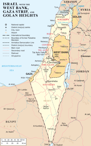
English: Map of Israel, the Palestinian territories (West Bank and Gaza Strip), the Golan Heights, and portions of neighbouring countries. Also United Nations deployment areas in countries adjoining Israel or Israeli-held territory, as of January 2004.
العربية: خريطة إسرائيل والأراضي الفلسطينية (الضفة الغربية وقطاع غزة) ومرتفعات الجولان وأجزاء من الدول المجاورة. وكذلك مناطق انتشار الأمم المتحدة في البلدان المجاورة لإسرائيل أو الأراضي التي تسيطر عليها إسرائيل ، حتى كانون الثاني / يناير 2004.
Datum
Vir http://www.un.org/Depts/Cartographic/map/profile/israel.pdf (heavily modified)
Avtor ChrisO
Druge različice

Izpeljana dela te datoteke:

File:Map of Israel, neighbours and occupied territories.svg je vektorska različica te datoteke. Kjer je primernejša, naj se uporablja namesto te rastrske slike.


Več informacij o vektorski grafiki je na voljo na strani Commons:Transition to SVG.
Na voljo so tudi informacije o podprtosti SVG-slik v programju MediaWiki.

V drugih jezikih
Alemannisch  Bahasa Indonesia  Bahasa Melayu  British English  català  čeština  dansk  Deutsch  eesti  English  español  Esperanto  euskara  français  Frysk  galego  hrvatski  Ido  italiano  lietuvių  magyar  Nederlands  norsk bokmål  norsk nynorsk  occitan  Plattdüütsch  polski  português  português do Brasil  română  Scots  sicilianu  slovenčina  slovenščina  suomi  svenska  Tiếng Việt  Türkçe  vèneto  Ελληνικά  беларуская (тарашкевіца)  български  македонски  нохчийн  русский  српски / srpski  татарча/tatarça  українська  ქართული  հայերեն  বাংলা  தமிழ்  മലയാളം  ไทย  한국어  日本語  简体中文  繁體中文  עברית  العربية  فارسی  +/−
Nova SVG-slika

Licenca

Public domain To delo je dal v javno domeno njegov avtor ChrisO, sodelavec projekta Wikipedija (jezik: angleščina).. To velja po vsem svetu.
V nekaterih državah to pravno morda ni mogoče. Če je tako,
ChrisO daje (v okviru zakonskih omejitev) vsakomur brezpogojno pravico, da gradivo uporablja v kateri koli namen.
Public domain This image is a map derived from a United Nations map.

Unless stated otherwise, UN maps are to be considered in the public domain. This applies worldwide.
Some UN maps have special copyrights, as indicated on the map itself.

UN maps are, in principle, open source material and you can use them in your work or for making your own map. UN requests however that you delete the UN name, logo and reference number upon any modification to the map. Content of your map will be your responsibility. You can state in your publication, if you wish, something like: based on UN map … (map name, map number, revision number and date). See: Geospatial Information Section. And: Geospatial, location data for a better world.

Izvorni dnevniški zapis naložitve

Izvorna opisna stran je bila tukaj. Vsa nadaljnja uporabniška imena se nanašajo na en.wikipedia.
  • 2007-04-03 22:53 ChrisO 1428×2289×8 (264824 bytes) == Summary == {{Information |Description= {{en|Map of [[Israel]], the [http://en.wikipedia.org/wiki/Palestinian_territories Palestinian territories] ([[West Bank]] and [[Gaza Strip]]), the [[Golan Heights]], and portions of neighbouring countries. Also [[

Napisi

Dodajte enovrstični opis, kaj ta datoteka predstavlja

Predmeti, prikazani v tej datoteki

motiv

3. april 2007

Zgodovina datoteke

Kliknite datum in čas za ogled datoteke, ki je bila takrat naložena.

Datum in časSličicaVelikostUporabnikKomentar
trenutno12:54, 12. marec 2012Sličica za različico z datumom 12:54, 12. marec 20121.428 × 2.289 (259 KB)Ayin leZionMarked J'lem as capital according to en:Israel
10:22, 11. april 2007Sličica za različico z datumom 10:22, 11. april 20071.428 × 2.289 (259 KB)Liftarn{{Information |Description=Map of Israel, the Palestinian territories (West Bank and Gaza Strip), the Golan Heights, and portions of neighbouring countries. Also United Nations deployment areas in countries adjoining Israel or Israeli-held territory, as o

Datoteka je del naslednje 1 strani slovenske Wikipedije (strani drugih projektov niso navedene):

Globalna uporaba datoteke

To datoteko uporabljajo tudi naslednji vikiji:

Oglejte si globalno uporabo te datoteke.

Metapodatki