
Slika:Timor island.jpg

Izvorna datoteka (640 × 640 točk, velikost datoteke: 149 KB, MIME-vrsta: image/jpeg)
Spodaj prikazane informacije so s tamkajšnje opisne strani.
Povzetek
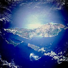
- Description: STS033-082-071 Timor Island, Indonesia November 1989.
Timor Island, one of the larger islands of the Lesser Sunda Islands, is located between the Savu Sea to the northwest and the Timor Sea to the southeast. The western half of the island, under Dutch control until 1949, and the eastern half, a Portuguese province until 1975, are now united as a province of Indonesia. Timor Island is approximately 300 miles (480 kilometers) long and 10 to 65 miles (16 to 105 kilometers) wide. Timor and the north-northwest arc of islands around the eastern end of the Banda Sea, all volcanic in origin, are in an unstable region of the world because of the intersection of three major tectonic plates northeast near Irian Jaya, Indonesia. Although it is located in the tropics, Timor Island has a definite dry season during the winter. Large forested volcanic mountains exist; however, much of the landscape lacks dense stands of tropical forest or jungle. Major cash crops include coffee, sandalwood, and copra.
This almost totally cloud free, photo of the island of Timor, Indonesia (9.0S, 125.0E) illustrates the volcanic origin of the over 1500 islands of Indonesia. Close examination of the photo reveals several eroded volcanoes on the Island of Timor and several of the adjacent islands. The linear alignment of the volcanoes, as seen from space, indicates the edges of the tectonic plates of the Earth's crust where volcanic activity is most common.
- Photo #: STS033-82-71
- Date: Nov. 1989
- Source: eol.jsc.nasa.gov
To sliko ali ta video je katalogiziral eden od centrov Nacionalne uprave za aeronavtiko in vesolje (NASA) Združenih držav Amerike pod oznako fotografije: STS033-082-071. Ta predloga ne označuje avtorskopravnega stanja dela. Ob njej mora stati tudi običajna oznaka avtorskopravnega stanja gradiva. Glejte Commons:Navedba licence. Drugi jeziki:
|
Licenca
| Ta datoteka je v javni domeni, ker jo je izdelala izključno NASA. Avtorskopravna politika NASE pravi, da »Gradivo NASE ni zaščiteno z avtorskimi pravicami, razen če je rečeno drugače.« (glej Template:PD-USGov, stran z avtorskopravno politiko NASE ali Politiko uporabe slik JPL.) | ||
 |
Opozorila:
|
Zgodovina datoteke
Kliknite datum in čas za ogled datoteke, ki je bila takrat naložena.
| Datum in čas | Sličica | Velikost | Uporabnik | Komentar | |
|---|---|---|---|---|---|
| trenutno | 04:27, 19. oktober 2005 | | 640 × 640 (149 KB) | Lofor | http://en.wikipedia.org/wiki/Image:Timor_island.jpg |
Uporaba datoteke
Datoteka ni del nobene strani slovenske Wikipedije.
Globalna uporaba datoteke
To datoteko uporabljajo tudi naslednji vikiji:
- Uporaba na be-tarask.wikipedia.org
- Uporaba na de.wikinews.org
- Uporaba na en.wikinews.org
- Uporaba na no.wikipedia.org
- Uporaba na or.wikipedia.org