
Slika:Stonehenge World Heritage Site map 2.svg

Velikost tega predogleda PNG datoteke SVG: 497 × 600 točk. Druge ločljivosti: 199 × 240 točk | 398 × 480 točk | 636 × 768 točk | 848 × 1.024 točk | 1.696 × 2.048 točk | 1.438 × 1.736 točk.
Izvorna datoteka (Datoteka SVG, nominalno 1.438 × 1.736 pikslov, velikost datoteke: 1,57 MB)
Spodaj prikazane informacije so s tamkajšnje opisne strani.
Povzetek
| Opis |
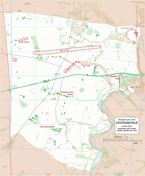
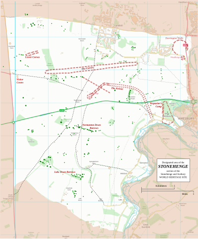
English: Boundary and key sites on the Avebury section of the Stonehenge, Avebury and Associated Sites World Heritage Site |
| Datum | |
| Vir | OS Open Data with additional material cited at World Heritage Site list No 373 |
| Avtor | RobinLeicester building on OS OpenData VextorMap District Raster files |
| Lokacija fotoaparata | | Ta in druge slike po lokaciji: OpenStreetMap |
|---|
Principal monuments and earthworks are shown in Red. Barrows are indicated by green dots.
Licenca
This file is licensed by the Ordnance Survey of the United Kingdom under their OS OpenData License
In short: you are free to distribute and modify the file as long as you attribute (including year), the Ordnance Survey. Avtorstvo: Contains Ordnance Survey data © Crown copyright and database right (year) Note: Derivative works can be licensed under any Creative Commons Attribution 3.0 Licence. |
_(St_Edwards_Crown).svg)
|
This file is licensed under the United Kingdom Open Government Licence v3.0. |
See also: Meta for information on usage on Wikimedia wikis.
|
Zgodovina datoteke
Kliknite datum in čas za ogled datoteke, ki je bila takrat naložena.
| Datum in čas | Sličica | Velikost | Uporabnik | Komentar | |
|---|---|---|---|---|---|
| trenutno | 00:36, 14. januar 2015 | | 1.438 × 1.736 (1,57 MB) | RobinLeicester | User created page with UploadWizard |
Uporaba datoteke
Datoteka je del naslednje 1 strani slovenske Wikipedije (strani drugih projektov niso navedene):
Globalna uporaba datoteke
To datoteko uporabljajo tudi naslednji vikiji:
- Uporaba na cs.wikipedia.org
- Uporaba na de.wikipedia.org
- Uporaba na en.wikipedia.org
- Uporaba na fi.wikipedia.org
- Uporaba na fr.wikipedia.org
- Uporaba na fr.wikivoyage.org
- Uporaba na ja.wikipedia.org
- Uporaba na kw.wikipedia.org
- Uporaba na nl.wikipedia.org
- Uporaba na ru.wikipedia.org
- Uporaba na simple.wikipedia.org
- Uporaba na ur.wikipedia.org
- Uporaba na zh.wikipedia.org