
Slika:Pleistocene north ice map.jpg

Višja ločljivost ni na voljo.
Pleistocene_north_ice_map.jpg (250 × 417 točk, velikost datoteke: 38 KB, MIME-vrsta: image/jpeg)
Spodaj prikazane informacije so s tamkajšnje opisne strani.
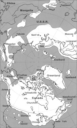
The maximum extent of glacial ice in the north polar area during Pleistocene time.
This image is in the public domain in the United States because it only contains materials that originally came from the United States Geological Survey, an agency of the United States Department of the Interior. For more information, see the official USGS copyright policy.
|
Zgodovina datoteke
Kliknite datum in čas za ogled datoteke, ki je bila takrat naložena.
| Datum in čas | Sličica | Velikost | Uporabnik | Komentar | |
|---|---|---|---|---|---|
| trenutno | 22:23, 11. junij 2005 | | 250 × 417 (38 KB) | Samulili | The maximum extent of glacial ice in the north polar area during Pleistocene time. {{PD-USGov-Interior-USGS}} http://pubs.usgs.gov/gip/continents/map.jpg |
Uporaba datoteke
Datoteka je del naslednje 1 strani slovenske Wikipedije (strani drugih projektov niso navedene):
Globalna uporaba datoteke
To datoteko uporabljajo tudi naslednji vikiji:
- Uporaba na bs.wikipedia.org
- Uporaba na ca.wikipedia.org
- Uporaba na cs.wikipedia.org
- Uporaba na en.wikipedia.org
- Uporaba na en.wikibooks.org
- Uporaba na eo.wikipedia.org
- Uporaba na es.wikipedia.org
- Uporaba na eu.wikipedia.org
- Uporaba na fa.wikipedia.org
- Uporaba na fi.wikipedia.org
- Uporaba na fi.wikibooks.org
- Uporaba na fr.wikipedia.org
- Uporaba na hr.wikipedia.org
- Uporaba na hu.wikipedia.org
- Uporaba na id.wikipedia.org
- Uporaba na it.wikipedia.org
- Uporaba na ja.wikipedia.org
- Uporaba na ka.wikipedia.org
- Uporaba na lfn.wikipedia.org
- Uporaba na ru.wikipedia.org
- Uporaba na sh.wikipedia.org
- Uporaba na te.wikipedia.org
- Uporaba na th.wikipedia.org
- Uporaba na tr.wikipedia.org
- Uporaba na uk.wikipedia.org
- Uporaba na vi.wikipedia.org
- Uporaba na xmf.wikipedia.org
- Uporaba na zh.wikipedia.org