
Slika:Newcaledonia tmo 2012268 lrg.jpg

Izvorna datoteka (2.800 × 2.200 točk, velikost datoteke: 849 KB, MIME-vrsta: image/jpeg)
Spodaj prikazane informacije so s tamkajšnje opisne strani.
Povzetek
| Opis |
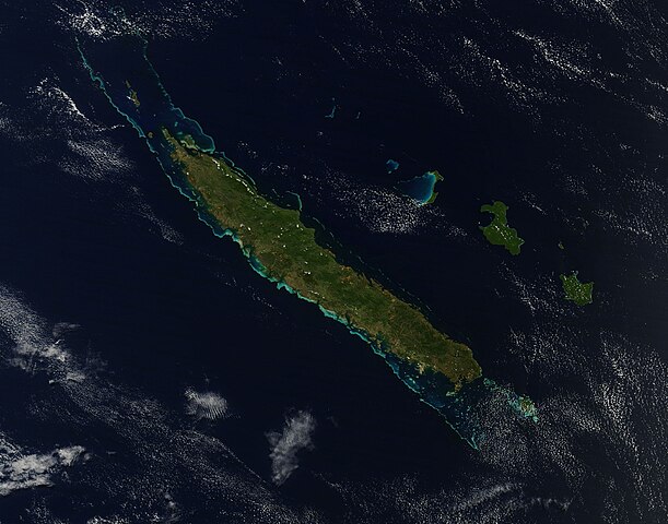
English: Roughly 1,300 kilometers (830 miles) east of Australia lies Grande Terre, the largest island of New Caledonia. The island is roughly 400 kilometers (250 miles) long and ringed by a 1,600-kilometer (1,000-mile) coral reef.
Cloud-free skies allowed the Moderate Resolution Imaging Spectroradiometer (MODIS) on NASA’s Terra satellite a clear view of Grande Terre on September 24, 2012. Coral reefs, appearing iridescent blue-green through the seawater, surround the mostly vegetation-coated island. New Caledonia has a hot and humid climate, but conditions vary between the coasts of Grande Terre. Trade winds from the southeast bring relatively cool, moist air to the eastern part of the island, where rich forests fill the coastal strip east of the mountains. In the west lie open, arid plains. Between the east and west coasts, a mountain range forms the island’s spine. The tallest point is Mont Panié with an elevation of 1,628 meters (5,341 feet) above sea level. The British explorer James Cook gave New Caledonia its name because its mountains reminded him of Scotland (once named Caledonia). In the years since his expedition, geologists have teased New Caledonia’s history from clues in the rock record. New Caledona was once a part of Gondwana, an ancient supercontinent that broke apart tens of millions of years ago. New Caledonia drifted northeastward and finally settled in its current position about 50 million years ago. Between 45 and 33 million years ago, tectonic plates colliding with each other uplifted the region, including part of the sea floor. Once elevated, New Caledonia began to erode, thanks to the action of wind and water. New Caledonia’s rocks are unusually rich in iron, magnesium, and nickel; in fact, the island is home to about a quarter of the world’s known nickel resources. Meanwhile the soils are poor in nitrogen, calcium, phosphorus, and potassium, and plant life has had to adapt. About 75 percent of New Caledonia’s plant species are found only the island, placing New Caledonia third, after Hawaii and New Zealand, for endemic plant species. Marine life around New Caledonia rivals the unique plant life. The United Nations Educational, Scientific and Cultural Organization (UNESCO) characterizes the reef system as “the world’s most diverse concentration of reef structures.” The reef, mangrove, and seagrass habitats provide homes to fish, marine invertebrates, marine mammals (such as whales and dugongs), and turtles. |
| Datum | UTC |
| Vir | http://earthobservatory.nasa.gov/IOTD/view.php?id=79389 |
| Avtor | NASA image courtesy Jeff Schmaltz, LANCE MODIS Rapid Response Team at NASA GSFC. Caption by Michon Scott. |
Licenca
| Ta datoteka je v javni domeni, ker jo je izdelala izključno NASA. Avtorskopravna politika NASE pravi, da »Gradivo NASE ni zaščiteno z avtorskimi pravicami, razen če je rečeno drugače.« (glej Template:PD-USGov, stran z avtorskopravno politiko NASE ali Politiko uporabe slik JPL.) | ||
 |
Opozorila:
|
Zgodovina datoteke
Kliknite datum in čas za ogled datoteke, ki je bila takrat naložena.
| Datum in čas | Sličica | Velikost | Uporabnik | Komentar | |
|---|---|---|---|---|---|
| trenutno | 20:32, 14. oktober 2012 | | 2.800 × 2.200 (849 KB) | Melikamp | User created page with UploadWizard |
Uporaba datoteke
Datoteka je del naslednje 1 strani slovenske Wikipedije (strani drugih projektov niso navedene):
Globalna uporaba datoteke
To datoteko uporabljajo tudi naslednji vikiji:
- Uporaba na af.wikipedia.org
- Uporaba na cs.wikipedia.org
- Uporaba na da.wikipedia.org
- Uporaba na el.wikipedia.org
- Uporaba na en.wikipedia.org
- Uporaba na fr.wikipedia.org
- Uporaba na he.wikipedia.org
- Uporaba na ja.wikipedia.org
- Uporaba na ka.wikipedia.org
- Uporaba na lt.wikipedia.org
- Uporaba na mi.wikipedia.org
- Uporaba na no.wikipedia.org
- Uporaba na oc.wikipedia.org
- Uporaba na sv.wikipedia.org
- Uporaba na zh.wikipedia.org