
Slika:NE 600ad.jpg
Izvorna datoteka (1.439 × 1.086 točk, velikost datoteke: 1,14 MB, MIME-vrsta: image/jpeg)
Spodaj prikazane informacije so s tamkajšnje opisne strani.
Povzetek
| Opis |
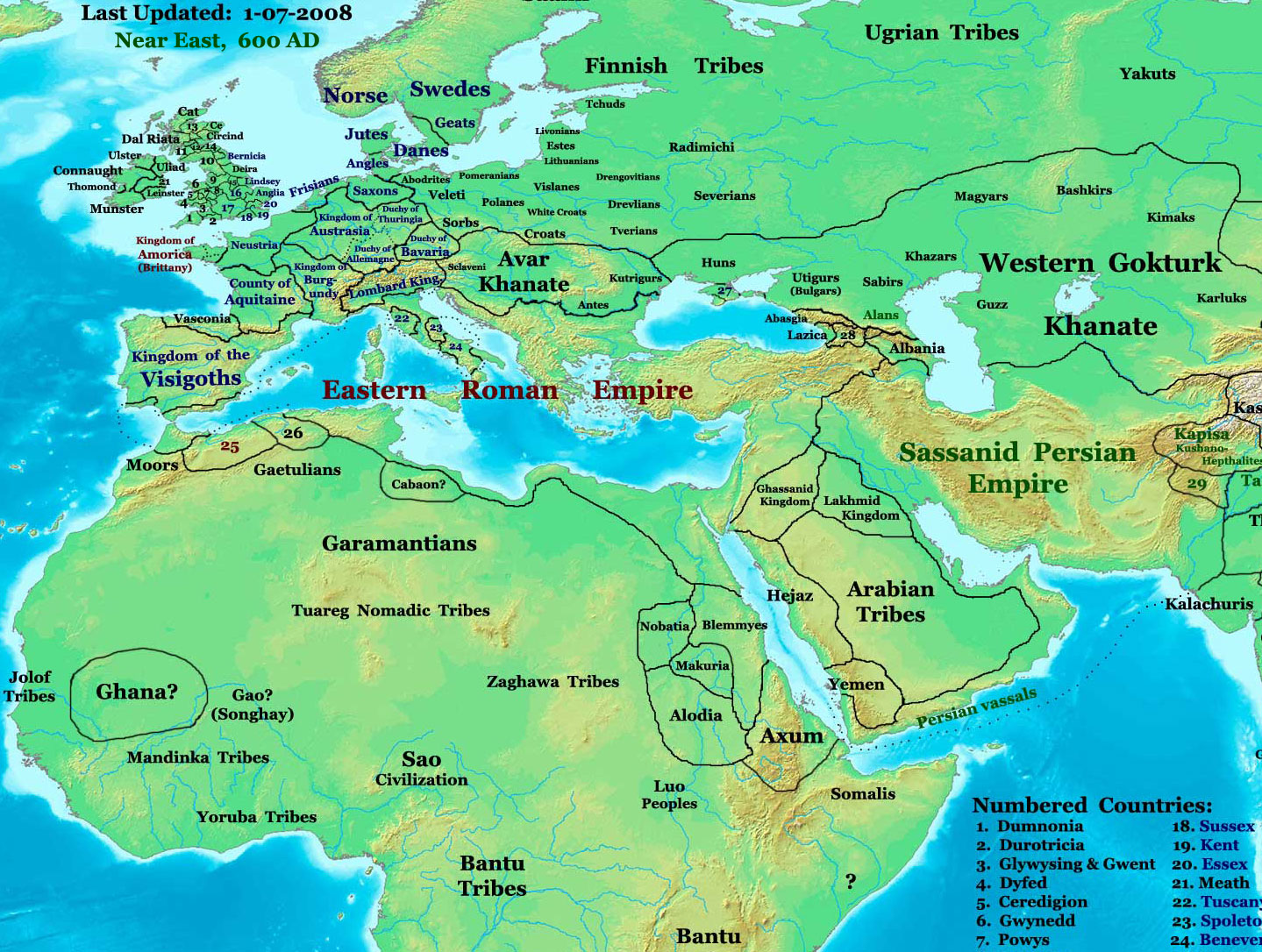
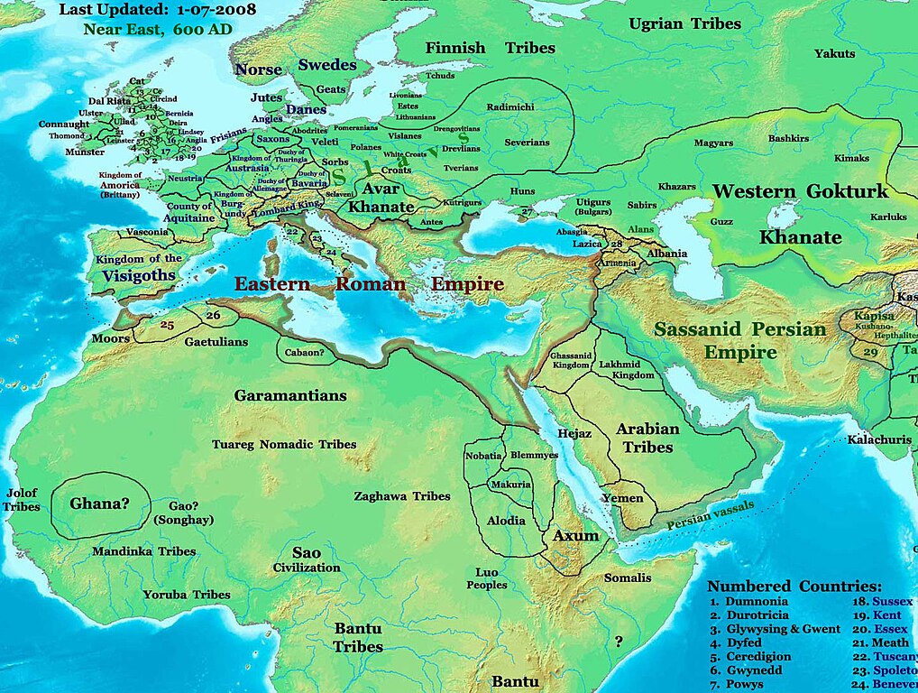
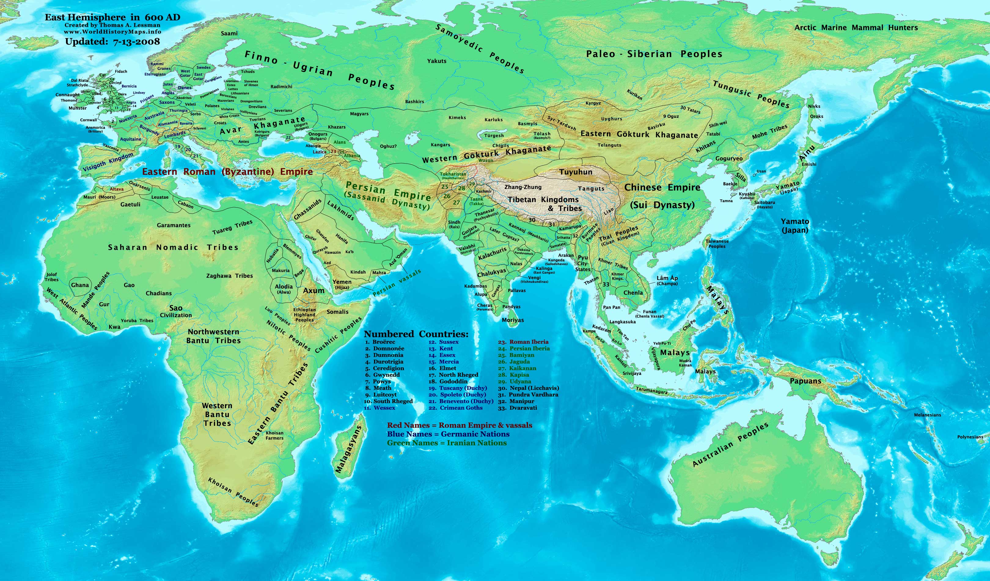
English: part of: Eastern Hemisphere in 600 AD.
Description: This image is a zoomed-in version of the Eastern Hemisphere in 600 AD. Author: Thomas A. Lessman (talessman@yis.us), later modified by others. Source URL: http://www.worldhistorymaps.info/images/East-Hem_600ad.jpg. Image Summary:Created by Thomas Lessman, based on this map of Eastern Hemisphere in 600 AD. Free for educational use. If you use this image, please credit the author (Thomas Lessman) and include (Source URL: http://www.worldhistorymaps.info/images/East-Hem_600ad.jpg). If you can help improve this map, please contact Thomas Lessman at talessman@yis.us. Other Historical Maps by Thomas Lessman
|
|||||||||||||||||||||||||
| Datum | 17. januarja 2008 (izvirni datum naložitve) | |||||||||||||||||||||||||
| Vir | Iz en.wikipedia v Zbirko. | |||||||||||||||||||||||||
| Avtor | Talessman, sodelavec projekta Wikipedija (jezik: angleščina). | |||||||||||||||||||||||||
| Dovoljenje (Nadaljnja uporaba datoteke) |
|
|||||||||||||||||||||||||
| Druge različice | Disputed map because the version with « Romanised Dacians » (= Olahok, Vlachs) and « Slavs » (Totok, Slavons, Slovens...) may be a romanian and slavic POV, but this « Only Avars and no other people north of the Danube, in the future Kingdom of Hungary », according to the Eduard Rössler's « Awarenwüste » theory, shows an Austrian-Hungarian POV: one is not more objective than the other and unfortunately no synthesis is possible. | |||||||||||||||||||||||||
Licenca

|
Ta dokument je dovoljeno kopirati, razširjati in/ali spreminjati pod pogoji Licence GNU za prosto dokumentacijo, različica 1.2 ali katera koli poznejša, ki jo je objavila ustanova Free Software Foundation; brez nespremenljivih delov ter brez besedil na sprednji ali zadnji platnici. Kopija licence je vključena v razdelek Licenca GNU za prosto dokumentacijo. |
| Datoteka je objavljena pod licenco Creative Commons Priznanje avtorstva-Deljenje pod enakimi pogoji 3.0 Nedoločena. | ||
| Avtorstvo: Talessman at the English Wikipedia | ||
| ||
| Ta oznaka dovoljenja je bila datoteki dodana kot del posodobitve licence GFDL. |
| Maps of the eastern hemisphere showing history
Bold dates are available on Wikimedia or Wikipedia. | ||
| Primeval | ||
| Ancient
|
·| 600 BC | 550 BC | 527 BC | 500 BC |
400 BC | ·| 1 AD | 50 AD | 100 AD | 200 AD | 300 AD | | |
| Medieval |
·| 500 AD | 565 AD | 600 AD | 700 AD | | |
| Modern |
·| 1500 AD | · * For historical maps of the whole world, | |
·
Izvorni dnevniški zapis naložitve
- 2008-01-17 20:07 Talessman 1439×1086× (513542 bytes) Added more info for Africa, corrected some info on Europe.
- 2007-11-02 18:55 Talessman 1450×988× (440135 bytes) Corrected borders in Africa/Sudan and Arabia.
- 2007-10-31 20:30 Talessman 1429×927× (437106 bytes) Corrected borders of Ghana, made other names easier to read, other misc. corrections.
- 2007-10-21 00:19 Talessman 1251×779× (341469 bytes) Author: Thomas A. Lessman. Source URL: http://www.ThomasLessman.com/History/images/East-Hem_600ad.jpg. Image was created by me (Thomas Lessman) based on map of Eastern Hemisphere in 600ad. Image is free for public and/or educational use. I would appreciat
Zgodovina datoteke
Kliknite datum in čas za ogled datoteke, ki je bila takrat naložena.
| Datum in čas | Sličica | Velikost | Uporabnik | Komentar | |
|---|---|---|---|---|---|
| trenutno | 19:26, 7. marec 2024 | | 1.439 × 1.086 (1,14 MB) | Nihil scimus | Restored a more accurate map uploaded march 15, 2023 by Moodylo333: Armenia was not Byzantine (see Claude Murafian's & Eric Van Lauwe's ''Atlas historique de l'Arménie'', Autrement publ., ISBN 2746701006); Highlighted the boundaries of the Eastern Roman Empire, Sassanid Persia and the Göktürk Khanate; Drawn the Slavic perimeter and reduced the Avar perimeter (greatly exaggerated) according to [https://commons.wikimedia.org/wiki/File:Avar_settlement_area.jpg] and to Vladislav Popovic's «La des... |
| 21:28, 26. september 2023 |  | 1.439 × 1.086 (502 KB) | OrionNimrod | Reverted to version as of 09:20, 1 February 2009 (UTC) keep original | |
| 18:28, 15. marec 2023 |  | 1.439 × 1.086 (1,14 MB) | Moodylo333 | More accurate map: see explanations. | |
| 15:38, 28. oktober 2022 |  | 1.439 × 1.086 (502 KB) | OrionNimrod | Reverted to version as of 09:20, 1 February 2009 (UTC) "Romance Dacians in 600" in Transylvania is clearly a Romanian nationalist POV, and there is Avar archeological sites, but the Avar territory was decreased in the updated map. Dacians in 600??? | |
| 17:47, 27. oktober 2022 |  | 1.439 × 1.086 (744 KB) | Nihil scimus | Modifications from academic historical books do not "invent nations" or falsifie Commons' digital incomplete maps, but enrich them. | |
| 19:29, 6. oktober 2022 |  | 1.439 × 1.086 (502 KB) | OrionNimrod | Reverted to version as of 09:20, 1 February 2009 (UTC) restored the original one which was extract from the big original map, the map was falsified with did not exist nations at that time 600 AD | |
| 14:55, 11. december 2014 |  | 1.439 × 1.086 (744 KB) | Spiridon Ion Cepleanu | Garamantian & Arabic tribes areas | |
| 19:26, 20. november 2014 |  | 1.439 × 1.086 (742 KB) | Spiridon Ion Cepleanu | Lakes & Caspian shorelines | |
| 15:21, 15. november 2014 |  | 1.439 × 1.086 (737 KB) | Spiridon Ion Cepleanu | Add missing names: Altava, Warsenia, Iberia, Kaikanan | |
| 15:00, 15. november 2014 |  | 1.439 × 1.086 (736 KB) | Spiridon Ion Cepleanu | Little cosmetic adds (seas names in this time, etc) |
Uporaba datoteke
Datoteka je del naslednjih 2 strani slovenske Wikipedije (strani drugih projektov niso navedene):
Globalna uporaba datoteke
To datoteko uporabljajo tudi naslednji vikiji:
- Uporaba na ast.wikipedia.org
- Uporaba na az.wikipedia.org
- Uporaba na ba.wikipedia.org
- Uporaba na bg.wikipedia.org
- Uporaba na ca.wikipedia.org
- Uporaba na cv.wikipedia.org
- Uporaba na el.wikipedia.org
- Uporaba na en.wikipedia.org
- Uporaba na en.wikiversity.org
- Uporaba na es.wikipedia.org
- Uporaba na fa.wikipedia.org
- Uporaba na fr.wikipedia.org
- Uporaba na hu.wikipedia.org
- Uporaba na id.wikipedia.org
- Uporaba na it.wikipedia.org
- Uporaba na ja.wikipedia.org
- Uporaba na ko.wikipedia.org
Oglejte si globalno uporabo te datoteke.