
Slika:Mtcook.nz.750pix.jpg
Izvorna datoteka (6.108 × 5.637 točk, velikost datoteke: 4,66 MB, MIME-vrsta: image/jpeg)
Spodaj prikazane informacije so s tamkajšnje opisne strani.
Povzetek
| Opis |
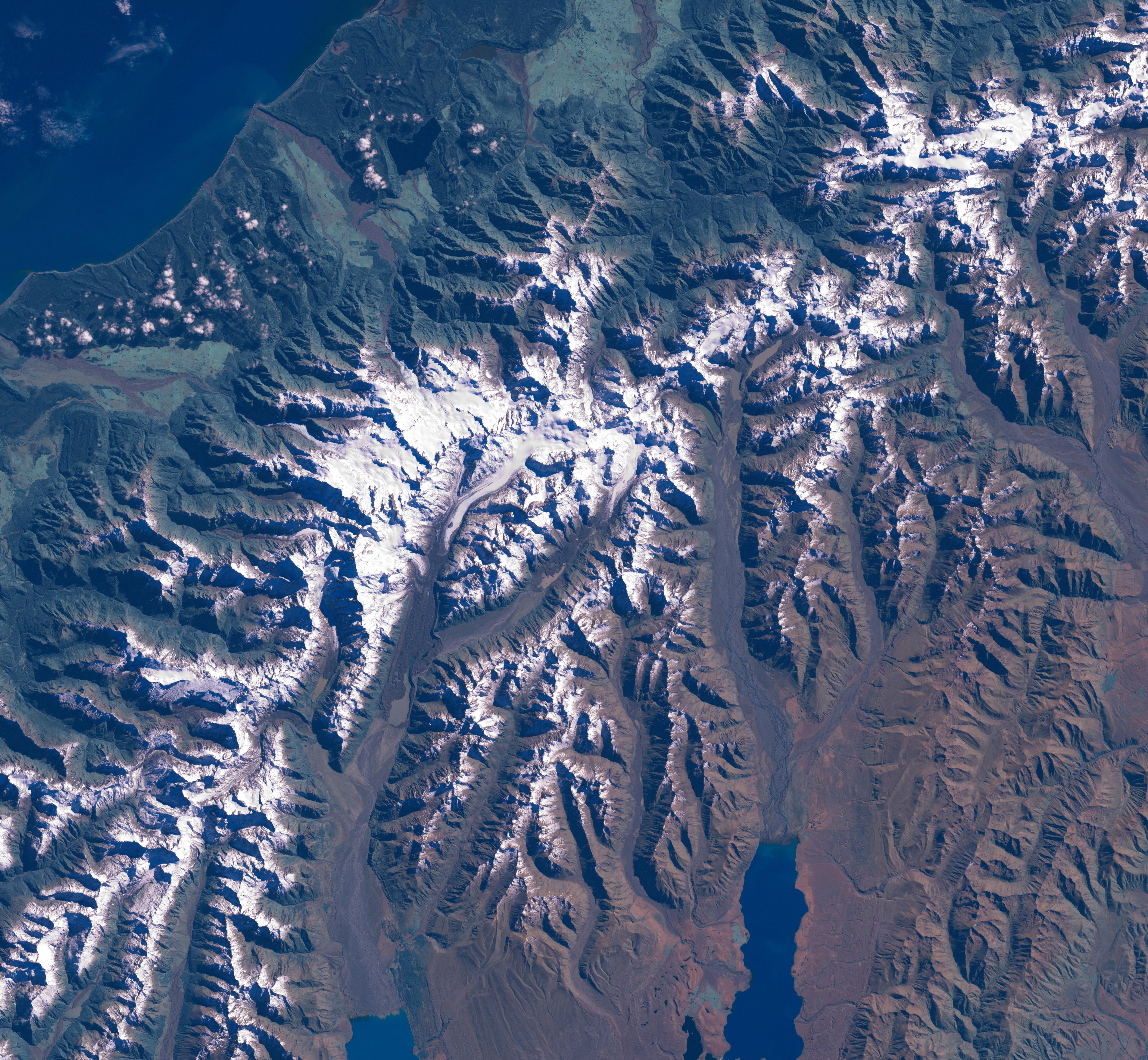
The Aoraki/Mount Cook area from LandSat. This image was acquired by Landsat 7's Enhanced Thematic Mapper plus (ETM ) sensor on March 31, 2001. This is a true-color image made using red, green, and blue wavelengths (ETM bands 3, 2, and 1). The image has also been pan-sharpened to heighten the details and resolution. |
| Vir |
SOURCE:
http://earthobservatory.nasa.gov/Newsroom/NewImages/images.php3?img_id=15331
This image was acquired by Landsat 7's Enhanced Thematic Mapper plus (ETM ) sensor on March 31, 2001. This is a true-color image made using red, green, and blue wavelengths (ETM bands 3, 2, and 1). The image has also been pan-sharpened to heighten the details and resolution. ”The purpose of NASA's Earth Observatory is to provide a freely-accessible publication on the Internet where the public can obtain new satellite imagery and scientific information about our home planet. The focus is on Earth's climate and environmental change. In particular, we hope our site is useful to public media and educators. Any and all materials published on the Earth Observatory are freely available for re-publication or re-use, except where copyright is indicated. We ask that NASA's Earth Observatory be given credit for its original materials.” |
| Avtor | Picture prepared for Wikipedia by Adrian Pingstone in November 2003. |
| Dovoljenje (Nadaljnja uporaba datoteke) |
PD |
Original authors
- Source: en.wikipedia.org
- Upload Tool Operator: Flominator (Flominator)
- Image contributor(s): Arpingstone
- 17:49, 7 November 2003 Arpingstone 750×750 (116,804 bytes) (Mount Cook from LandSat)
Licenca
| Ta datoteka je v javni domeni, ker jo je izdelala izključno NASA. Avtorskopravna politika NASE pravi, da »Gradivo NASE ni zaščiteno z avtorskimi pravicami, razen če je rečeno drugače.« (glej Template:PD-USGov, stran z avtorskopravno politiko NASE ali Politiko uporabe slik JPL.) | ||
 |
Opozorila:
|
Zgodovina datoteke
Kliknite datum in čas za ogled datoteke, ki je bila takrat naložena.
| Datum in čas | Sličica | Velikost | Uporabnik | Komentar | |
|---|---|---|---|---|---|
| trenutno | 18:20, 24. februar 2007 | | 6.108 × 5.637 (4,66 MB) | Tom | higher res and w/o english words |
| 10:32, 29. avgust 2006 |  | 750 × 750 (114 KB) | CommonismNow | {{Information| |Description=This image was acquired by Landsat 7's Enhanced Thematic Mapper plus (ETM ) sensor on March 31, 2001. This is a true-color image made using red, green, and blue wavelengths (ETM bands 3, 2, and 1). The image has also been pan- |
Uporaba datoteke
Datoteka je del naslednje 1 strani slovenske Wikipedije (strani drugih projektov niso navedene):
Globalna uporaba datoteke
To datoteko uporabljajo tudi naslednji vikiji:
- Uporaba na ar.wikipedia.org
- Uporaba na bg.wikipedia.org
- Uporaba na bn.wikipedia.org
- Uporaba na ca.wikipedia.org
- Uporaba na cy.wikipedia.org
- Uporaba na da.wikipedia.org
- Uporaba na de.wikipedia.org
- Uporaba na en.wikipedia.org
- Uporaba na es.wikipedia.org
- Uporaba na eu.wikipedia.org
- Uporaba na hr.wikipedia.org
- Uporaba na ja.wikipedia.org
- Uporaba na mt.wikipedia.org
- Uporaba na nn.wikipedia.org
- Uporaba na pt.wikipedia.org
- Uporaba na sh.wikipedia.org