
Slika:Mackenzie river enters Beaufort sea.jpg

Izvorna datoteka (9.000 × 7.500 točk, velikost datoteke: 64 MB, MIME-vrsta: image/jpeg)
Spodaj prikazane informacije so s tamkajšnje opisne strani.
Povzetek
| Opis |
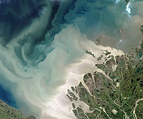
English: The Mackenzie River is the leading source of freshwater flowing into the Arctic Ocean. It's also a leading source of sediment flowing into that basin.
The Operational Land Imager (OLI) on the Landsat 8 satellite acquired this image of the Mackenzie Delta on July 19, 2017. At the time, the Beaufort Sea was colored with milky, tan brush strokes of sediment in various levels of dispersal after pouring out of the river. The Mackenzie is the largest and longest northward-flowing river in North America, and the second largest on the continent (after the Mississippi). The watershed drains a huge, but mostly unsettled portion of Canada; population density along the 4,200 kilometer (2,600 mile) river is just 1 person per square kilometer. About 7 percent of the fresh water that flows into the Arctic Ocean each year comes out the Mackenzie and its delta, and much of that comes in large pulses in June and July after the freshet—when inland ice and snow melts and floods the river. The spring flood carries with it tremendous amounts of dissolved organic material and sediment. More info & refs at source. |
| Datum | acquired July 19, 2017 |
| Vir | https://earthobservatory.nasa.gov/IOTD/view.php?id=90703&src=eoa-iotd |
| Avtor | NASA Earth Observatory images by Jesse Allen, using Landsat data from the U.S. Geological Survey |
Licenca
| Ta datoteka je v javni domeni, ker jo je izdelala izključno NASA. Avtorskopravna politika NASE pravi, da »Gradivo NASE ni zaščiteno z avtorskimi pravicami, razen če je rečeno drugače.« (glej Template:PD-USGov, stran z avtorskopravno politiko NASE ali Politiko uporabe slik JPL.) | ||
 |
Opozorila:
|
Zgodovina datoteke
Kliknite datum in čas za ogled datoteke, ki je bila takrat naložena.
| Datum in čas | Sličica | Velikost | Uporabnik | Komentar | |
|---|---|---|---|---|---|
| trenutno | 09:28, 7. januar 2021 | | 9.000 × 7.500 (64 MB) | StellarHalo | higher resolution |
| 07:25, 9. avgust 2017 |  | 720 × 600 (276 KB) | Tillman | {{Information |Description ={{en|1=The Mackenzie River is the leading source of freshwater flowing into the Arctic Ocean. It's also a leading source of sediment flowing into that basin. The Operational Land Imager (OLI) on the Landsat 8 satellite a... |
Uporaba datoteke
Datoteka je del naslednjih 2 strani slovenske Wikipedije (strani drugih projektov niso navedene):
Globalna uporaba datoteke
To datoteko uporabljajo tudi naslednji vikiji:
- Uporaba na de.wikipedia.org
- Uporaba na en.wikipedia.org
- Uporaba na uz.wikipedia.org