
Slika:Itasy lake.jpg
Višja ločljivost ni na voljo.
Itasy_lake.jpg (268 × 178 točk, velikost datoteke: 16 KB, MIME-vrsta: image/jpeg)
Spodaj prikazane informacije so s tamkajšnje opisne strani.
Povzetek
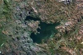
| Opis |
English: The Itasy volcanic field in central Madagascar.
|
| Datum | neznan datum |
| Vir | http://www.volcano.si.edu/world/volcano.cfm?vnum=0303-014&volpage=photos&photo=114074 |
| Avtor | NASA Landsat7 image (worldwind.arc.nasa.gov) |
| Druge različice |

Licenca
| This image is in the public domain because it is a screenshot from NASA’s globe software World Wind using a public domain layer, such as Blue Marble, MODIS, Landsat, SRTM, USGS or GLOBE.
|
 |
Zgodovina datoteke
Kliknite datum in čas za ogled datoteke, ki je bila takrat naložena.
| Datum in čas | Sličica | Velikost | Uporabnik | Komentar | |
|---|---|---|---|---|---|
| trenutno | 11:47, 1. februar 2022 | | 268 × 178 (16 KB) | Proeksad | File:Itasy Volcanic Field.jpg cropped 58 % horizontally, 58 % vertically using CropTool with precise mode. |
Uporaba datoteke
Datoteka je del naslednje 1 strani slovenske Wikipedije (strani drugih projektov niso navedene):
Globalna uporaba datoteke
To datoteko uporabljajo tudi naslednji vikiji:
- Uporaba na ceb.wikipedia.org
- Uporaba na en.wikipedia.org
- Uporaba na fr.wikipedia.org
- Uporaba na hr.wikipedia.org
- Uporaba na mg.wikipedia.org
- Uporaba na nl.wikipedia.org
- Uporaba na ru.wikipedia.org
- Uporaba na www.wikidata.org