Pojdi na vsebino

Slika:Deposition erosion.jpg

Vsebina strani ni podprta v drugih jezikih.
Iz Wikipedije, proste enciklopedije

Izvorna datoteka(900 × 989 točk, velikost datoteke: 113 KB, MIME-vrsta: image/jpeg)


je mogoče poustvariti z uporabo vektorske grafike kot SVG-datoteko. To ima več prednosti; več informacij je na razpolago na strani Commons:Media for cleanup. Če je SVG-oblika te datoteke že na razpolago, jo, prosimo, naložite. Potem, ko boste SVG naložili, to predlogo zamenjajte z izrazom {{vector version available|ime nove slike.svg}}.

Povzetek

Opis
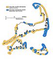
English: Map of Cape Cod showing those shores undergoing erosion (cliffed sections) in yellow, and shores characterized by marine deposition (barriers) in blue. Although the barriers are sites of marine deposition, in the long run, the ocean shore will retreat as the barrier keeps pace with the erosion of cliffed shorelines and as they adjust to sea-level rise.
Datum
Vir U.S. Geological Survey
Avtor Robert N. Oldale
Lokacija fotoaparata41° 41′ 06,5″ S, 70° 18′ 00,5″ Z Kartographer map based on OpenStreetMap.Ta in druge slike po lokaciji: OpenStreetMapinfo

Licenca

Public domain
This image is in the public domain in the United States because it only contains materials that originally came from the United States Geological Survey, an agency of the United States Department of the Interior. For more information, see the official USGS copyright policy.

Bahasa Indonesia  català  čeština  Deutsch  eesti  English  español  français  galego  italiano  Nederlands  português  polski  sicilianu  suomi  Tiếng Việt  Türkçe  български  македонски  русский  മലയാളം  한국어  日本語  中文  中文(简体)  中文(繁體)  العربية  فارسی  +/−

Napisi

Dodajte enovrstični opis, kaj ta datoteka predstavlja

Predmeti, prikazani v tej datoteki

motiv

41°41'6.500"N, 70°18'0.500"W

Zgodovina datoteke

Kliknite datum in čas za ogled datoteke, ki je bila takrat naložena.

Datum in časSličicaVelikostUporabnikKomentar
trenutno00:40, 11. oktober 2016Sličica za različico z datumom 00:40, 11. oktober 2016900 × 989 (113 KB)GrolltechAnisotrophic filter to smooth noise, larger image; shift colors for better accessibility to colorblind persons.
02:48, 30. avgust 2011Sličica za različico z datumom 02:48, 30. avgust 2011600 × 659 (66 KB)GrolltechAdded color to the original black & white diagram, to more clearly indicate areas of erosion and deposition.
15:16, 11. september 2009Sličica za različico z datumom 15:16, 11. september 2009600 × 659 (112 KB)Grolltech{{Information |Description={{en|1=Map of Cape Cod showing shores undergoing erosion (cliffed sections) and shores characterized by marine deposition (barriers). Although the barriers are sites of marine deposition, in the long run, the ocean shore will re

Datoteka je del naslednje 1 strani slovenske Wikipedije (strani drugih projektov niso navedene):

Globalna uporaba datoteke

To datoteko uporabljajo tudi naslednji vikiji: