
Slika:Cyprus2022OSM.png
Velikost tega predogleda: 800 × 522 točk. Druge ločljivosti: 320 × 209 točk | 640 × 418 točk | 1.024 × 669 točk | 1.280 × 836 točk | 2.560 × 1.671 točk | 4.212 × 2.750 točk.
Izvorna datoteka (4.212 × 2.750 točk, velikost datoteke: 2,67 MB, MIME-vrsta: image/png)
Spodaj prikazane informacije so s tamkajšnje opisne strani.
Povzetek
| Opis |
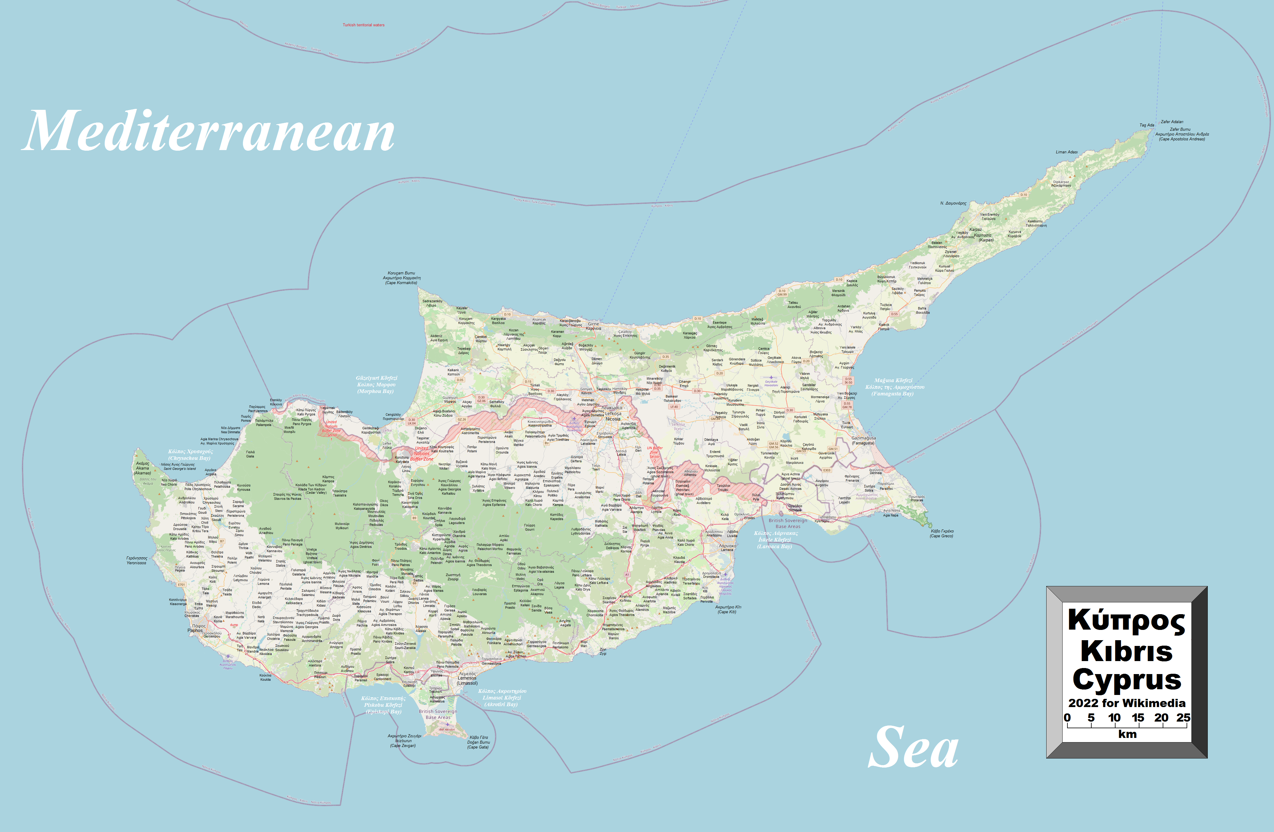
English: This map of Cyprus shows the country's cities, towns, villages and some other geographical details, and is likely the most comprehensive map of the country in this respect that you'll find anywhere online. It has been stitched together from panels of Open Street Map (which is freely licensed to all) with details plotted by the uploader, among which are a great number of inhabited places (and even the odd uninhabited place), the British Sovereign Base Areas, the United Nations Buffer Zone along with the Green Line (shown, however, in red and purple, respectively), coastal features and a few other things (see if you can spot the word "dump" on the map). A lack of room made it impossible to include all the information that users might like to see. To avoid having too much clutter on the map, places in the self-declared republic in the north are given their Turkish names with their Greek names underneath (without Latin-script transliteration), while places still under the southern republic's administration are given their Greek names with Latin-script transliterations underneath (finding their Turkish names was a bit of a problem). In a very few cases, English names (if different) are also given. Also, not absolutely every village has been included. |
| Datum | |
| Vir | lastno delo |
| Avtor | Kelisi |
| Dovoljenje (Nadaljnja uporaba datoteke) |
The aforesaid website is freely usable to all. |
Licenca
Jaz, imetnik avtorskih pravic na tem delu, ga objavljam pod naslednjo licenco:
Datoteka je objavljena pod licenco Creative Commons Priznanje avtorstva-Deljenje pod enakimi pogoji 4.0 Mednarodno.
- Dovoljeno vam je:
- deljenje – reproducirati, distribuirati in javno priobčevati delo
- predelava – predelati delo
- Pod naslednjimi pogoji:
- priznanje avtorstva – Navesti morate ustrezno avtorstvo, povezavo do licence in morebitne spremembe. To lahko storite na kakršen koli primeren način, vendar ne na način, ki bi nakazoval, da dajalec licence podpira vas ali vašo uporabo dela.
- deljenje pod enakimi pogoji – Če boste to vsebino predelali, preoblikovali ali uporabili kot izhodišče za drugo delo, morate svoj prispevek distribuirati pod enako ali združljivo licenco, kot jo ima izvirnik.
Zgodovina datoteke
Kliknite datum in čas za ogled datoteke, ki je bila takrat naložena.
| Datum in čas | Sličica | Velikost | Uporabnik | Komentar | |
|---|---|---|---|---|---|
| trenutno | 21:46, 21. maj 2022 | | 4.212 × 2.750 (2,67 MB) | Kelisi | Uploaded own work with UploadWizard |
Uporaba datoteke
Datoteka je del naslednje 1 strani slovenske Wikipedije (strani drugih projektov niso navedene):
Globalna uporaba datoteke
To datoteko uporabljajo tudi naslednji vikiji:
- Uporaba na en.wikipedia.org
- Uporaba na lt.wikipedia.org