
Slika:Bolohoveni land from A.V. Boldur description.PNG
Višja ločljivost ni na voljo.
Bolohoveni_land_from_A.V._Boldur_description.PNG (278 × 267 točk, velikost datoteke: 115 KB, MIME-vrsta: image/png)
Spodaj prikazane informacije so s tamkajšnje opisne strani.
Povzetek
| Opis |
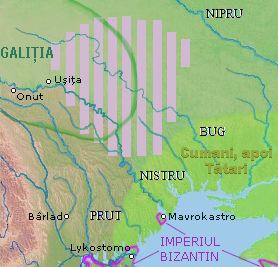
English: a map of a historical region, between Nistru and Nipru rivers, Northern Black Sea. |
| Datum | |
| Vir |
in May 7, 2013, only for Wiki pages |
| Avtor | Eurocentral, background from NASA - drawing generated since data from NASA Johnson Space Center - Earth Sciences and Image Analysis (NASA-JSC-ES&IA) ([1] Mission-Roll-Frame ISS001-E-5577, NASA Shuttle Radar Topography Mission (SRTM30) and/or Natural Earth, PD) |
| Datoteka je na voljo pod licenco Creative Commons Univerzalna izročitev v javno domeno CC0 1.0 | |
| Oseba, ki je delo povezala s tem dovoljenjem, je dala svoje delo v javno domeno z opustitvijo vseh svojih pravic do dela po vsem svetu pod avtorskim pravom, vključno z vsemi povezanimi in sorodnimi pravicami, v obsegu, kot ga dopušča zakonodaja. Delo lahko kopirate, spreminjate, razširjate in izvajate, tudi v gospodarske namene, ne da bi morali zaprositi za dovoljenje.
|
Zgodovina datoteke
Kliknite datum in čas za ogled datoteke, ki je bila takrat naložena.
| Datum in čas | Sličica | Velikost | Uporabnik | Komentar | |
|---|---|---|---|---|---|
| trenutno | 05:00, 17. september 2021 | | 278 × 267 (115 KB) | Trecătorul răcit | Left the cities, remove their hypothetic borders |
| 20:25, 13. julij 2016 |  | 278 × 267 (115 KB) | Julieta39 | More colours, Cumans & later Tatars | |
| 22:42, 30. marec 2014 |  | 278 × 267 (112 KB) | Spiridon Ion Cepleanu | More details according with Nicolae Iorga & Alexandru Boldur | |
| 08:30, 8. maj 2013 |  | 278 × 320 (116 KB) | Eurocentral | {{subst:Upload marker added by en.wp UW}} {{Information |Description = {{en|a map of a historical region, between Nistru and Nipru rivers, Northern Black Sea.}} |Source = in May 7, 2013, only for Wiki pages<br/> '''Previously published:''' only for Wik... |
Uporaba datoteke
Datoteka je del naslednje 1 strani slovenske Wikipedije (strani drugih projektov niso navedene):
Globalna uporaba datoteke
To datoteko uporabljajo tudi naslednji vikiji:
- Uporaba na en.wikipedia.org
- Uporaba na ro.wikipedia.org
- Uporaba na ru.wikipedia.org
- Uporaba na sr.wikipedia.org
- Uporaba na uk.wikipedia.org
- Uporaba na www.wikidata.org