
Slika:Africa-countries-northern.png
Višja ločljivost ni na voljo.
Africa-countries-northern.png (360 × 392 točk, velikost datoteke: 10 KB, MIME-vrsta: image/png)
Spodaj prikazane informacije so s tamkajšnje opisne strani.

|
File:Africa-countries-northern.svg je vektorska različica te datoteke. Kjer je primernejša, naj se uporablja namesto te rastrske slike.
File:Africa-countries-northern.png → File:Africa-countries-northern.svg
Več informacij o vektorski grafiki je na voljo na strani Commons:Transition to SVG. Na voljo so tudi informacije o podprtosti SVG-slik v programju MediaWiki. |
 |
Povzetek
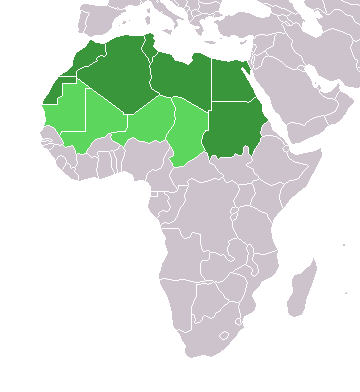
English: Map of countries in geo-political North Africa — as considered by the U.N.
- Credits
from en:Image:Africa-countries-northern.png

|
Ta dokument je dovoljeno kopirati, razširjati in/ali spreminjati pod pogoji Licence GNU za prosto dokumentacijo, različica 1.2 ali katera koli poznejša, ki jo je objavila ustanova Free Software Foundation; brez nespremenljivih delov ter brez besedil na sprednji ali zadnji platnici. Kopija licence je vključena v razdelek Licenca GNU za prosto dokumentacijo. |
| Datoteka je objavljena pod licenco Creative Commons Priznanje avtorstva-Deljenje pod enakimi pogoji 3.0 Brez predelav. | ||
| ||
| Ta oznaka dovoljenja je bila datoteki dodana kot del posodobitve licence GFDL. |
Zgodovina datoteke
Kliknite datum in čas za ogled datoteke, ki je bila takrat naložena.
| Datum in čas | Sličica | Velikost | Uporabnik | Komentar | |
|---|---|---|---|---|---|
| trenutno | 17:22, 17. marec 2018 | | 360 × 392 (10 KB) | Maphobbyist | Montenegro border |
| 23:00, 31. marec 2016 |  | 360 × 392 (10 KB) | Fry1989 | Reverted to version as of 16:12, 13 January 2014 (UTC) | |
| 11:37, 7. november 2015 |  | 360 × 392 (10 KB) | Hpyounes | correction | |
| 18:12, 13. januar 2014 |  | 360 × 392 (10 KB) | VVVF | See http://unstats.un.org/unsd/methods/m49/m49regin.htm | |
| 17:59, 13. januar 2014 |  | 360 × 392 (13 KB) | VVVF | Reverted to version as of 20:15, 9 July 2011. See http://unstats.un.org/unsd/methods/m49/m49regin.htm | |
| 14:47, 20. julij 2011 |  | 360 × 392 (7 KB) | Kahusi | See http://unstats.un.org/unsd/methods/m49/m49regin.htm | |
| 22:15, 9. julij 2011 |  | 360 × 392 (13 KB) | Maphobbyist | South Sudan has become independent on July 9, 2011. Sudan and South Sudan are shown with the new international border between them. | |
| 13:13, 5. maj 2006 |  | 360 × 392 (4 KB) | Hautala | optimized with png | |
| 18:30, 20. april 2005 |  | 360 × 392 (14 KB) | Yonghokim | map of countries in Northern Africa. from en:Image:Africa-countries-northern.png {{GFDL}} |
Uporaba datoteke
Datoteka ni del nobene strani slovenske Wikipedije.
Globalna uporaba datoteke
To datoteko uporabljajo tudi naslednji vikiji:
- Uporaba na ce.wikipedia.org
- Uporaba na es.wikipedia.org
- Uporaba na fr.wikipedia.org
- Uporaba na he.wikipedia.org
- Uporaba na ru.wikipedia.org
- Uporaba na sc.wikipedia.org
- Uporaba na sv.wikinews.org