
Slika:A Map of Europe for the Illustration of King Alfred's Anglo-Saxon translation of Orosius. Engraved by J. Bayly.jpg

Izvorna datoteka (3.254 × 3.220 točk, velikost datoteke: 1,97 MB, MIME-vrsta: image/jpeg)
Spodaj prikazane informacije so s tamkajšnje opisne strani.
Povzetek
| Opis |
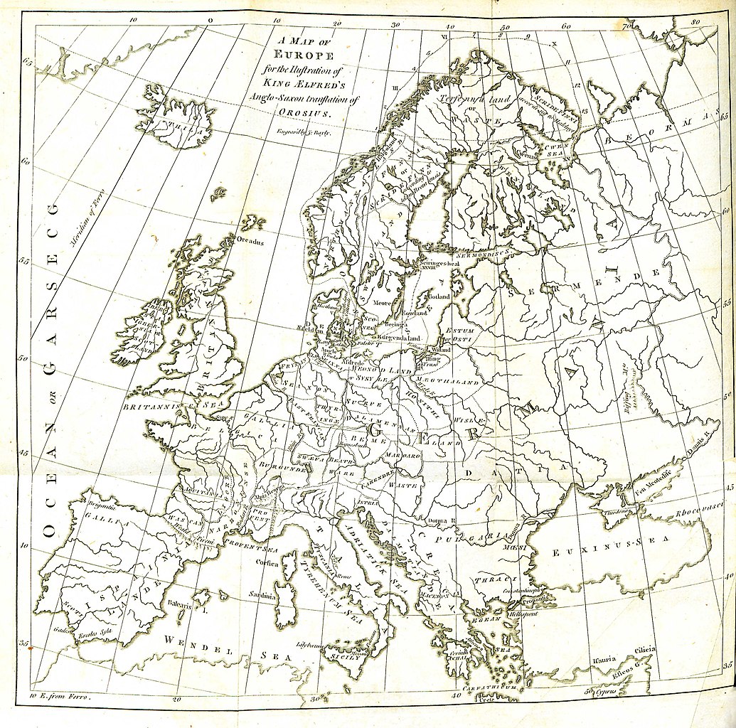
English: Folding engraved map published in: Daines Barrington (ed./transl.), King Ælfred’s Orosius: The Anglo-Saxon Version, from the Historian Orosius. By Ælfred the Great. Together with an English Translation from the Anglo-Saxon. London: printed by W. Bowyer and J. Nichols: and sold by S. Baker and G. Leigh; T. Payne; and B. White, 1773, II, after p. 260. Drawn up by Johann Reinhold Forster and his son Georg Forster (uncredited, see: Johann Reinhold Forster, Geschichte der Entdeckungen und Schiffahrten im Norden. Frankfurt an der Oder: Carl Gottlieb Strauß, 1784, pp. XIII–XIV, and: Walter Goffart, Historical Atlases: The First Three Hundred Years, 1570–1870. Chicago/London: The University of Chicago Press, 2003, pp. 197, 200). Engraved by John Bayly. Description of the map (Barrington, op. cit., I, p. xxiv): |
| Vir | Daines Barrington (ed./transl.), King Ælfred’s Orosius: The Anglo-Saxon Version, from the Historian Orosius. By Ælfred the Great |
| Avtor | Drawn up by Johann Reinhold Forster and his son Georg Forster |
Licenca
|
To delo je v javni domeni tudi v državah in na območjih, kjer trajajo avtorske pravice za časa avtorjevega življenja in še 100 let ali manj po tem. Delo je v Združenih državah Amerike v javni domeni, saj je bilo objavljeno (ali registrirano pri Uradu za avtorske pravice ZDA) pred 1. januarjem 1929. | |
| Datoteka je bila prepoznana kot prosta omejitev po avtorskem pravu, vključno z vsemi povezanimi in sorodnimi pravicami. | |
| Annotations | This image is annotated: View the annotations at Commons |
Zgodovina datoteke
Kliknite datum in čas za ogled datoteke, ki je bila takrat naložena.
| Datum in čas | Sličica | Velikost | Uporabnik | Komentar | |
|---|---|---|---|---|---|
| trenutno | 13:11, 29. avgust 2016 | | 3.254 × 3.220 (1,97 MB) | BarringtonForster | Engraved folding map published in: Daines Barrington (ed./transl.), ''King Ælfred’s Orosius: The Anglo-Saxon Version, from the Historian Orosius. By Ælfred the Great. Together with an English Translation from the Anglo-Saxon''. London: printed by W... |
Uporaba datoteke
Datoteka je del naslednje 1 strani slovenske Wikipedije (strani drugih projektov niso navedene):
Globalna uporaba datoteke
To datoteko uporabljajo tudi naslednji vikiji:
- Uporaba na en.wikipedia.org
- Uporaba na lt.wikipedia.org
- Uporaba na pl.wikipedia.org
- Uporaba na pt.wikipedia.org