
Slika:Mazama bathymetry survey map.jpg
Višja ločljivost ni na voljo.
Mazama_bathymetry_survey_map.jpg (600 × 345 točk, velikost datoteke: 61 KB, MIME-vrsta: image/jpeg)
Spodaj prikazane informacije so s tamkajšnje opisne strani.
| Opis |
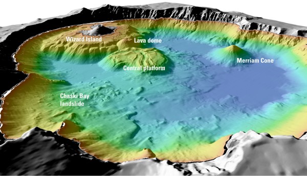
English: "Details of features beneath the surface of Crater Lake constructed using data from the 2000 bathymetry survey. Colors range from orange to blue with increasing water depth." |
| Vir | "Mount Mazama and Crater Lake: Growth and Destruction of a Cascade Volcano" |
| Avtor | U.S. Geological Survey |
Licenca
This image is in the public domain in the United States because it only contains materials that originally came from the United States Geological Survey, an agency of the United States Department of the Interior. For more information, see the official USGS copyright policy.
|
Izvorni dnevniški zapis naložitve
Izvorna opisna stran je bila tukaj. Vsa nadaljnja uporabniška imena se nanašajo na en.wikipedia.
- 2004-05-18 06:41 Mav 600×345× (62232 bytes) [[USGS]] image from [http://geopubs.wr.usgs.gov/fact-sheet/fs092-02/] <br><br>{{msg:PD}}
Zgodovina datoteke
Kliknite datum in čas za ogled datoteke, ki je bila takrat naložena.
| Datum in čas | Sličica | Velikost | Uporabnik | Komentar | |
|---|---|---|---|---|---|
| trenutno | 08:26, 13. julij 2009 | | 600 × 345 (61 KB) | ZabMilenko | {{Information |Description={{en|en:USGS image from [http://geopubs.wr.usgs.gov/fact-sheet/fs092-02/] en:Category:Images of Oregon}} |Source=Transferred from [http://en.wikipedia.org en.wikipedia]; transferred to Commons by [[User:ZabMilenko |
Uporaba datoteke
Datoteka je del naslednje 1 strani slovenske Wikipedije (strani drugih projektov niso navedene):
Globalna uporaba datoteke
To datoteko uporabljajo tudi naslednji vikiji:
- Uporaba na bh.wikipedia.org
- Uporaba na el.wikipedia.org
- Uporaba na en.wikipedia.org
- Uporaba na eo.wikipedia.org
- Uporaba na es.wikipedia.org
- Uporaba na fa.wikipedia.org
- Uporaba na it.wikipedia.org
- Uporaba na ja.wikipedia.org
- Uporaba na lv.wikipedia.org
- Uporaba na ms.wikipedia.org
- Uporaba na simple.wikipedia.org
- Uporaba na ur.wikipedia.org
- Uporaba na vi.wikipedia.org
- Uporaba na www.wikidata.org
- Uporaba na zh.wikipedia.org