
Slika:Map of CSA 4.png
Izvorna datoteka (1.200 × 609 točk, velikost datoteke: 421 KB, MIME-vrsta: image/png)
Spodaj prikazane informacije so s tamkajšnje opisne strani.

|
To sliko je mogoče poustvariti z uporabo vektorske grafike kot SVG-datoteko. To ima več prednosti; več informacij je na razpolago na strani Commons:Media for cleanup. Če je SVG-oblika te datoteke že na razpolago, jo, prosimo, naložite. Potem, ko boste SVG naložili, to predlogo zamenjajte z izrazom {{vector version available|ime nove slike.svg}}.
|
Povzetek
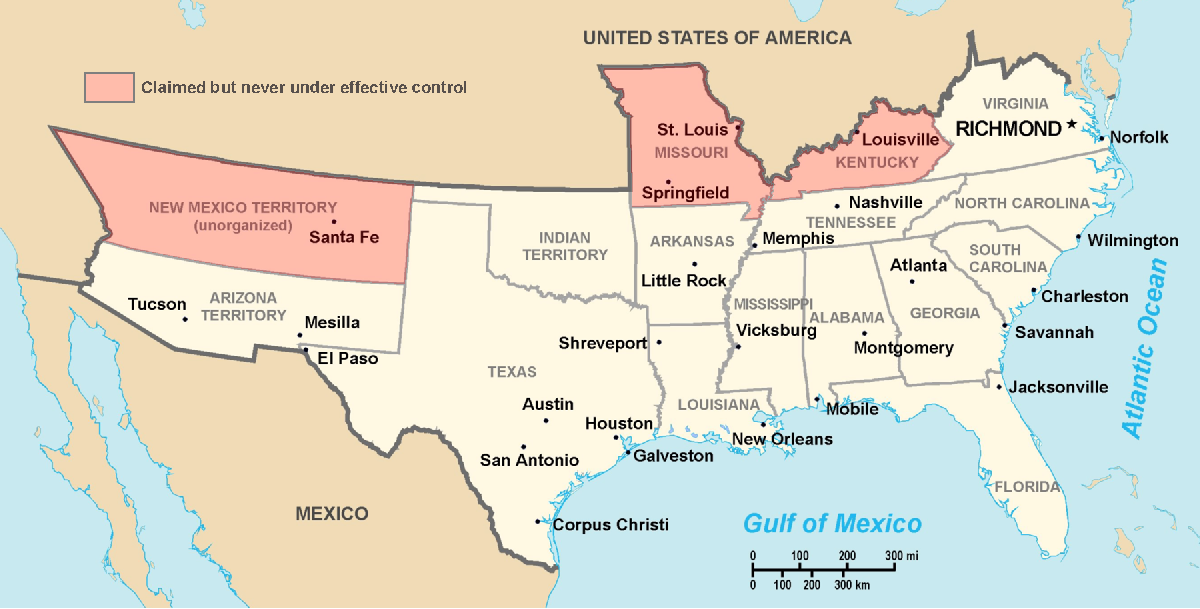
Historic Southern United States. The Confederate States have historically been regarded as forming "the South". States shown in light red are considered "border states", and gave varying degrees of support to the Southern cause although they remained in the Union. (This image depicts the original, trans-Allegheny borders of Virginia, and so does not show West Virginia separately. See the images above for post-1863 Virginia and West Virginia borders.) Although much of Indian Territory was aligned with the Confederacy, it had not yet been introduced into the Union as the state of Oklahoma. Drawn by Nicholas F Source en:wikipedia
Licenca
| |
To delo je njegov avtor Nicholas F v projektu Wikimedijina zbirka izročil oz. izroča tukaj v javno domeno. To velja po vsem svetu. Kjer to pravno ni mogoče, daje Nicholas F: |
Zgodovina datoteke
Kliknite datum in čas za ogled datoteke, ki je bila takrat naložena.
| Datum in čas | Sličica | Velikost | Uporabnik | Komentar | |
|---|---|---|---|---|---|
| trenutno | 01:22, 18. marec 2006 | | 1.200 × 609 (421 KB) | Fabrizio Fiorita~commonswiki | Drawn by Nicholas F Source en:wikipedia |
Uporaba datoteke
Datoteka je del naslednje 1 strani slovenske Wikipedije (strani drugih projektov niso navedene):
Globalna uporaba datoteke
To datoteko uporabljajo tudi naslednji vikiji:
- Uporaba na af.wikipedia.org
- Uporaba na ar.wikipedia.org
- Uporaba na ca.wikipedia.org
- Uporaba na de.wikipedia.org
- Uporaba na en.wikipedia.org
- Uporaba na eo.wikipedia.org
- Uporaba na et.wikipedia.org
- Uporaba na fi.wikipedia.org
- Uporaba na frr.wikipedia.org
- Uporaba na fy.wikipedia.org
- Uporaba na gl.wikipedia.org
- Uporaba na hu.wikipedia.org
- Uporaba na hy.wikipedia.org
- Uporaba na it.wikipedia.org
- Uporaba na ja.wikipedia.org
- Uporaba na la.wikipedia.org
- Uporaba na lfn.wikipedia.org
- Uporaba na lt.wikipedia.org
- Uporaba na lv.wikipedia.org
- Uporaba na ms.wikipedia.org
- Uporaba na nap.wikipedia.org
- Uporaba na no.wikipedia.org
- Uporaba na ro.wikipedia.org
- Uporaba na ru.wikipedia.org
- Uporaba na sv.wikipedia.org
- Uporaba na ta.wikipedia.org
- Uporaba na tr.wikipedia.org
- Uporaba na uk.wikipedia.org
- Uporaba na vi.wikipedia.org
- Uporaba na www.wikidata.org