
Slika:Khazar map1.PNG

Velikost tega predogleda: 800 × 504 točk. Druge ločljivosti: 320 × 202 točk | 640 × 403 točk | 939 × 592 točk.
Izvorna datoteka (939 × 592 točk, velikost datoteke: 548 KB, MIME-vrsta: image/png)
Spodaj prikazane informacije so s tamkajšnje opisne strani.
Povzetek
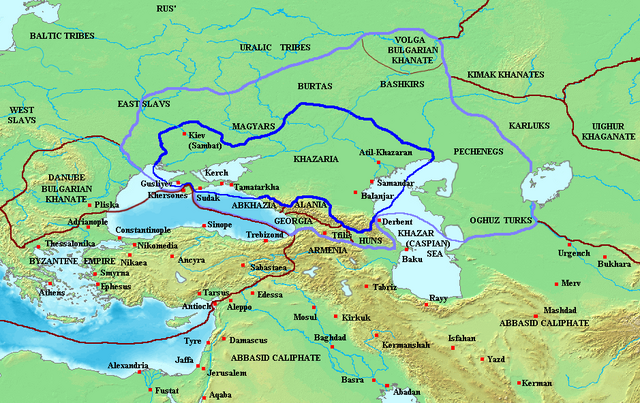
Map of the Khazar Khaganate and surrounding states, c. 820 CE. Area of direct Khazar control shown in dark blue, sphere of influence in purple. Other boundaries shown in dark red.
Made by User:Briangotts
Licenca
| Datoteka je objavljena pod licenco Creative Commons Priznanje avtorstva-Deljenje pod enakimi pogoji 3.0 Nedoločena. Predmet zanikanj odgovornosti. | ||
| ||
| Ta oznaka dovoljenja je bila datoteki dodana kot del posodobitve licence GFDL. |

|
Ta dokument je dovoljeno kopirati, razširjati in/ali spreminjati pod pogoji Licence GNU za prosto dokumentacijo, različica 1.2 ali katera koli poznejša, ki jo je objavila ustanova Free Software Foundation; brez nespremenljivih delov ter brez besedil na sprednji ali zadnji platnici. Kopija licence je vključena v razdelek Licenca GNU za prosto dokumentacijo. Predmet zanikanj odgovornosti. |
Zgodovina datoteke
Kliknite datum in čas za ogled datoteke, ki je bila takrat naložena.
| Datum in čas | Sličica | Velikost | Uporabnik | Komentar | |
|---|---|---|---|---|---|
| trenutno | 09:29, 26. junij 2023 | | 939 × 592 (548 KB) | Johannnes89 | Reverted to version as of 18:29, 20 May 2016 (UTC) crosswiki image spam, often containing historical inaccuracies |
| 01:56, 26. junij 2023 |  | 939 × 592 (657 KB) | Valdazleifr | Fixed a minor toponymycal error | |
| 20:29, 20. maj 2016 |  | 939 × 592 (548 KB) | Julieta39 | Lakes, rivers, shorelines of the time, cosmetic. | |
| 17:20, 27. oktober 2006 |  | 939 × 592 (336 KB) | Frode Inge Helland | == Summary == Map of the Khazar Khaganate and surrounding states, c. 820 CE. Area of direct Khazar control shown in dark blue, sphere of influence in purple. Other boundaries shown in dark red. Category:Historical maps by User:Briangotts == L | |
| 17:17, 27. oktober 2006 |  | 939 × 592 (336 KB) | Frode Inge Helland | == Summary == Map of the Khazar Khaganate and surrounding states, c. 820 CE. Area of direct Khazar control shown in dark blue, sphere of influence in purple. Other boundaries shown in dark red. Category:Historical maps by User:Briangotts == L |
Uporaba datoteke
Datoteka je del naslednjih 2 strani slovenske Wikipedije (strani drugih projektov niso navedene):
Globalna uporaba datoteke
To datoteko uporabljajo tudi naslednji vikiji:
- Uporaba na be-tarask.wikipedia.org
- Uporaba na da.wikipedia.org
- Uporaba na el.wikipedia.org
- Uporaba na en.wikipedia.org
- Uporaba na fr.wikipedia.org
- Uporaba na hu.wikipedia.org
- Uporaba na it.wikipedia.org
- Uporaba na ja.wikipedia.org
- Uporaba na mk.wikipedia.org
- Uporaba na no.wikipedia.org
- Uporaba na pnb.wikipedia.org
- Uporaba na tt.wikipedia.org
- Uporaba na uk.wikipedia.org
- Uporaba na zh.wikipedia.org