
Slika:Irrigation Project along the Orange River.jpg

Velikost tega predogleda: 526 × 599 točk. Druge ločljivosti: 211 × 240 točk | 421 × 480 točk | 674 × 768 točk | 898 × 1.024 točk | 1.797 × 2.048 točk | 3.159 × 3.600 točk.
Izvorna datoteka (3.159 × 3.600 točk, velikost datoteke: 2,84 MB, MIME-vrsta: image/jpeg)
Spodaj prikazane informacije so s tamkajšnje opisne strani.
Povzetek
| Opis |
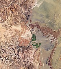
English: Along the banks of this river, roughly 100 kilometres inland from where the river empties into the Atlantic Ocean, irrigation projects take advantage of water from the river and soils from the floodplains to grow produce, turning parts of a normally earth-toned landscape emerald green. A network of bright rectangles of varying shades of green contrasts with surroundings of grey, beige, tan, and rust. Immediately south of a large collection of irrigated plots, faint beige circles reveal centre-pivot irrigation fields apparently allowed to go fallow. |
| Datum | |
| Vir | NASA Earth Observatory |
| Avtor | Jesse Allen |
Image captured by the Advanced Land Imager (ALI) on NASA’s Earth Observing-1 (EO-1) satellite.
Licenca
| Ta datoteka je v javni domeni, ker jo je izdelala izključno NASA. Avtorskopravna politika NASE pravi, da »Gradivo NASE ni zaščiteno z avtorskimi pravicami, razen če je rečeno drugače.« (glej Template:PD-USGov, stran z avtorskopravno politiko NASE ali Politiko uporabe slik JPL.) | ||
 |
Opozorila:
|
Zgodovina datoteke
Kliknite datum in čas za ogled datoteke, ki je bila takrat naložena.
| Datum in čas | Sličica | Velikost | Uporabnik | Komentar | |
|---|---|---|---|---|---|
| trenutno | 15:24, 8. marec 2010 | | 3.159 × 3.600 (2,84 MB) | Originalwana | {{Information |Description={{en|1=Along the banks of this river, roughly 100 kilometres inland from where the river empties into the Atlantic Ocean, irrigation projects take advantage of water from the river and soils from t |
Uporaba datoteke
Datoteka je del naslednje 1 strani slovenske Wikipedije (strani drugih projektov niso navedene):
Globalna uporaba datoteke
To datoteko uporabljajo tudi naslednji vikiji:
- Uporaba na ca.wikipedia.org
- Uporaba na en.wikipedia.org
- Uporaba na fi.wikipedia.org
- Uporaba na fr.wikipedia.org
- Uporaba na is.wikipedia.org