
Slika:Basin of Lop Nur 90.25E, 40.10N, Desert of Lop, Kum Tagh and Astin Tagh.jpg

Velikost tega predogleda: 800 × 520 točk. Druge ločljivosti: 320 × 208 točk | 640 × 416 točk | 1.024 × 666 točk | 1.280 × 832 točk | 2.539 × 1.651 točk.
Izvorna datoteka (2.539 × 1.651 točk, velikost datoteke: 2,5 MB, MIME-vrsta: image/jpeg)
Spodaj prikazane informacije so s tamkajšnje opisne strani.
Povzetek
| Opis |
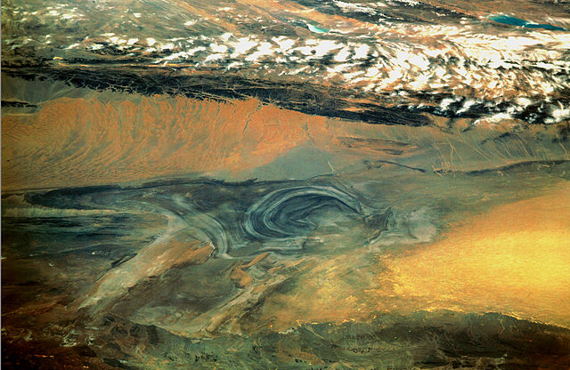
English: China, Xinjiang, desert Lop Nur. Satellite picture of the Basin of the formerly sea Lop Nur in the Desert of Lop. In the foreground Kuruktagh, in the background Kumtagh and Astintagh. A duststorm is blowing to the west over the Desert of Lop. Two lakes appear in a break in the clouds covering the Plateau of Astintagh. Visible are elongated Ayakkum Hu Lake south-southwest of Lop Nur and small blue-green Gas Hu Lake.
Deutsch: China, Xinjiang, Wüste Lop Nor. Satellitenaufnahme von dem mittleren Teil des Seebeckens Lop Nor und der Wüste Lop Nor, über die ein Sandsturm hinweggeht. Im Vordergrund sieht man die Hänge des Gebirges Kuruktagh, im Hintergrund die Hänge des Kumtagh und die Hochebene des Astintagh, auf der rechts der See Ayakkum Hu und links der kleinere See Gas Hu liegen. Blick von Norden Richtung Süden. |
| Datum | |
| Vir | NASA Mission: STS047, Roll-Frame 151 – 26, File name STS047-151-26.JPG. [1]. See also: [2]. |
| Avtor |
English: NASA. Image courtesy of Earth Sciences and Image Analysis Laboratory, NASA Johnson Space Center. Color adjusting of this image (using Adobe Photoshop 6.0): Michael Gaebler, 02. March 2006, own work, all rights released (Public domain).
Deutsch: Zugrunde liegt ein noch nicht farbrichtiges Astronauten-Foto der NASA. Diese Fotografie wurde von Michael Gaebler am 02. März 2006 im RGB-Modus mit Adobe Photoshop 6.0 mit Farb- und Tonwertkorrekturen überarbeitet. |
| Dovoljenje (Nadaljnja uporaba datoteke) |
PD-USGov-NASA |
![[1]](ftp://eol.jsc.nasa.gov/EFS_highres_STS047_STS047-151-26.JPG)
To sliko ali ta video je katalogiziral eden od centrov Nacionalne uprave za aeronavtiko in vesolje (NASA) Združenih držav Amerike pod oznako fotografije: STS047-151-26. Ta predloga ne označuje avtorskopravnega stanja dela. Ob njej mora stati tudi običajna oznaka avtorskopravnega stanja gradiva. Glejte Commons:Navedba licence. Drugi jeziki:
|
Licenca
| Ta datoteka je v javni domeni, ker jo je izdelala izključno NASA. Avtorskopravna politika NASE pravi, da »Gradivo NASE ni zaščiteno z avtorskimi pravicami, razen če je rečeno drugače.« (glej Template:PD-USGov, stran z avtorskopravno politiko NASE ali Politiko uporabe slik JPL.) | ||
 |
Opozorila:
|
Zgodovina datoteke
Kliknite datum in čas za ogled datoteke, ki je bila takrat naložena.
| Datum in čas | Sličica | Velikost | Uporabnik | Komentar | |
|---|---|---|---|---|---|
| trenutno | 00:46, 11. marec 2006 | | 2.539 × 1.651 (2,5 MB) | Michael Gäbler | {{Information| |Description = en: China, Xinjiang, desert Lop Nur. Satellite picture of the Basin of the formerly sea Lop Nur in the Desert of Lop. In the foreground Kuruktagh, in the background Kumtagh and Astintagh. A duststorm is blowing to th |
Uporaba datoteke
Datoteka je del naslednje 1 strani slovenske Wikipedije (strani drugih projektov niso navedene):
Globalna uporaba datoteke
To datoteko uporabljajo tudi naslednji vikiji:
- Uporaba na az.wikipedia.org
- Uporaba na de.wikipedia.org
- Uporaba na en.wikipedia.org
- Uporaba na en.wikibooks.org
- Uporaba na es.wikipedia.org
- Uporaba na fa.wikipedia.org
- Uporaba na frr.wikipedia.org
- Uporaba na he.wikivoyage.org
- Uporaba na hi.wikipedia.org
- Uporaba na id.wikipedia.org
- Uporaba na it.wikipedia.org
- Uporaba na ja.wikipedia.org
- Uporaba na ka.wikipedia.org
- Uporaba na ko.wikipedia.org
- Uporaba na mn.wikipedia.org
- Uporaba na pa.wikipedia.org
- Uporaba na pl.wikipedia.org
- Uporaba na pnb.wikipedia.org
- Uporaba na ro.wikipedia.org
- Uporaba na sh.wikipedia.org
- Uporaba na sr.wikipedia.org
- Uporaba na sv.wikipedia.org
- Uporaba na te.wikipedia.org
- Uporaba na tr.wikipedia.org
- Uporaba na ug.wikipedia.org
- Uporaba na uk.wikipedia.org
- Uporaba na ur.wikipedia.org
- Uporaba na www.wikidata.org
- Uporaba na zh.wikipedia.org