
Slika:Abies balsamea range map 3.png
Velikost tega predogleda: 799 × 599 točk. Druge ločljivosti: 320 × 240 točk | 640 × 480 točk | 1.024 × 768 točk | 1.280 × 960 točk | 2.560 × 1.920 točk | 5.926 × 4.445 točk.
Izvorna datoteka (5.926 × 4.445 točk, velikost datoteke: 456 KB, MIME-vrsta: image/png)
Spodaj prikazane informacije so s tamkajšnje opisne strani.
Povzetek
| Opis |
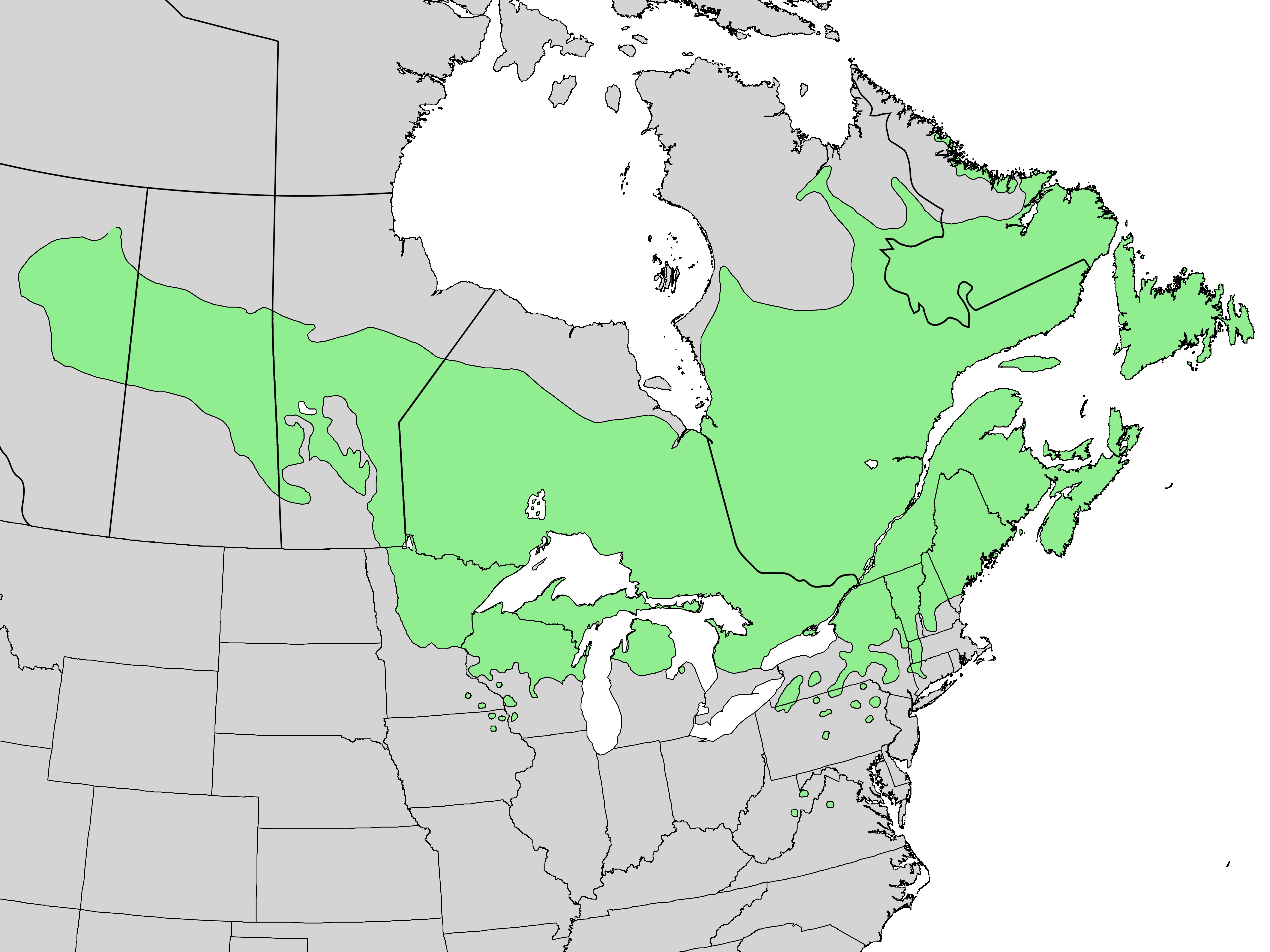
English: Distribution map for Abies balsamea (L.) Mill. - balsam fir |
| Datum | |
| Vir | USGS Geosciences and Environmental Change Science Center, Digital Representations of Tree Species Range Maps from "Atlas of United States Trees" by Elbert L. Little, Jr. (and other publications) |
| Avtor | Elbert L. Little, Jr., U.S. Department of Agriculture, Forest Service, and others |
Licenca
This image is in the public domain in the United States because it only contains materials that originally came from the United States Geological Survey, an agency of the United States Department of the Interior. For more information, see the official USGS copyright policy.
|
Zgodovina datoteke
Kliknite datum in čas za ogled datoteke, ki je bila takrat naložena.
| Datum in čas | Sličica | Velikost | Uporabnik | Komentar | |
|---|---|---|---|---|---|
| trenutno | 22:02, 14. december 2013 | | 5.926 × 4.445 (456 KB) | Nonenmac | higher-res, province borders, lakes white |
| 16:27, 20. marec 2013 |  | 2.974 × 1.983 (109 KB) | Nonenmac | User created page with UploadWizard |
Uporaba datoteke
Datoteka je del naslednje 1 strani slovenske Wikipedije (strani drugih projektov niso navedene):
Globalna uporaba datoteke
To datoteko uporabljajo tudi naslednji vikiji:
- Uporaba na arz.wikipedia.org
- Uporaba na ast.wikipedia.org
- Uporaba na be.wikipedia.org
- Uporaba na bg.wikipedia.org
- Uporaba na ca.wikipedia.org
- Uporaba na ceb.wikipedia.org
- Uporaba na cs.wikipedia.org
- Uporaba na de.wikipedia.org
- Uporaba na el.wikipedia.org
- Uporaba na en.wikipedia.org
- Uporaba na eo.wikipedia.org
- Uporaba na es.wikipedia.org
- Uporaba na et.wikipedia.org
- Uporaba na eu.wikipedia.org
- Uporaba na fa.wikipedia.org
- Uporaba na fr.wikipedia.org
- Uporaba na he.wikipedia.org
- Uporaba na hu.wikipedia.org
- Uporaba na hy.wikipedia.org
- Uporaba na is.wikipedia.org
- Uporaba na it.wikipedia.org
- Uporaba na koi.wikipedia.org
- Uporaba na lt.wikipedia.org
- Uporaba na nl.wikipedia.org
- Uporaba na no.wikipedia.org
- Uporaba na oc.wikipedia.org
- Uporaba na ro.wikipedia.org
- Uporaba na ru.wikipedia.org
- Uporaba na sv.wikipedia.org
- Uporaba na udm.wikipedia.org
- Uporaba na uk.wikipedia.org
- Uporaba na www.wikidata.org
- Uporaba na zh.wikipedia.org