
Slika:Wales in the UK and Europe.svg

Velikost tega predogleda PNG datoteke SVG: 713 × 600 točk. Druge ločljivosti: 285 × 240 točk | 571 × 480 točk | 913 × 768 točk | 1.218 × 1.024 točk | 2.435 × 2.048 točk | 2.045 × 1.720 točk.
Izvorna datoteka (Datoteka SVG, nominalno 2.045 × 1.720 pikslov, velikost datoteke: 7,84 MB)
Spodaj prikazane informacije so s tamkajšnje opisne strani.
Povzetek
| Opis |
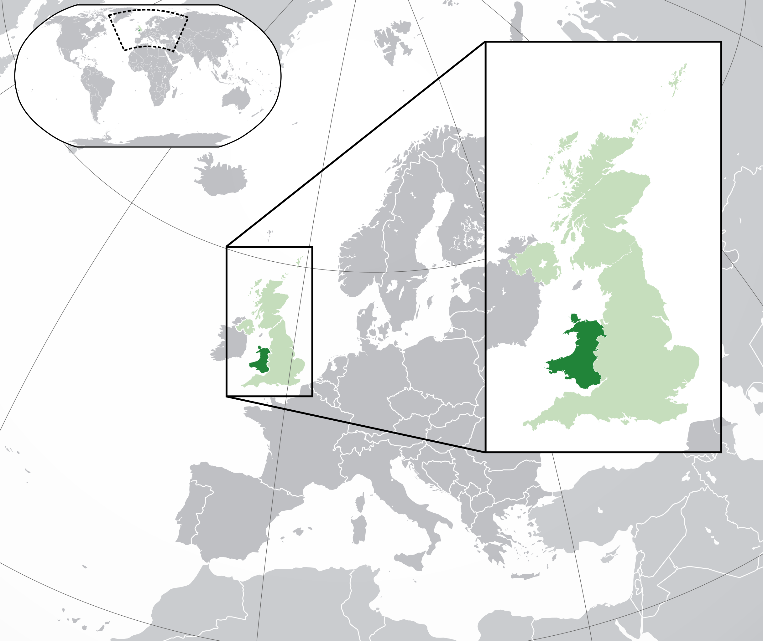
English: A map of Wales within the United Kingdom and Europe. The map is a polar orthographic projection.
Wales
United Kingdom (except Wales)
Europe (except UK) Français : Une carte du Pays de Galles au sein du Royaume-Uni et en Europe. La carte est un polair projection orthographique.
Pays de Galles
Royaume-Uni (sauf le Pays de Galles)
Europe (sauf le Royaume-Uni) Deutsch: Eine Karte der Wales drinnen das Vereinigtes Königreich und drinnen Europa. Die Karte ist ein polare orthografische Azimutalprojektion.
Wales
Vereinigtes Königreich (außer Wales)
Europa (außer das Vereinigtes Königreich) Cymraeg:
Cymru
Y Deyrnas Unedig
Ewrop Gàidhlig:
A' Chuimrigh
An Rìoghachd Aonaichte
An Roinn-Eòrpa Gaeilge:
An Bhreatain Bheag
An Ríocht Aontaithe
An Eoraip Kernowek: Kembra
Ruwvaneth Unys
Europa |
| Datum | (UTC) |
| Vir |
Ta datoteka je izpeljana iz: Blank map of Europe (with disputed regions).svg: |
| Avtor |
|
| Druge različice |
|
| SVG razvoj | Izvorna koda te velik SVG-datoteke ni veljavna zaradi 201 napak. Ta prevelika W3C-neveljavna vektorska slika je bila ustvarjena z Inkscape, or with something else. |


.svg)
Licenca
Datoteka je objavljena pod licenco Creative Commons Priznanje avtorstva-Deljenje pod enakimi pogoji 3.0 Nedoločena.
- Dovoljeno vam je:
- deljenje – reproducirati, distribuirati in javno priobčevati delo
- predelava – predelati delo
- Pod naslednjimi pogoji:
- priznanje avtorstva – Navesti morate ustrezno avtorstvo, povezavo do licence in morebitne spremembe. To lahko storite na kakršen koli primeren način, vendar ne na način, ki bi nakazoval, da dajalec licence podpira vas ali vašo uporabo dela.
- deljenje pod enakimi pogoji – Če boste to vsebino predelali, preoblikovali ali uporabili kot izhodišče za drugo delo, morate svoj prispevek distribuirati pod enako ali združljivo licenco, kot jo ima izvirnik.
Izvorni dnevniški zapis naložitve
This image is a derivative work of the following images:
- File:Blank_map_of_Europe.svg licensed with Cc-by-sa-2.5
- 2012-02-21T16:27:27Z Alphathon 680x520 (614699 Bytes) Updated Metadata and the boarders/coastlines along the western coast of the Black Sea
- 2011-09-19T22:57:58Z Alphathon 680x520 (603759 Bytes) Added North/Northern Cyprus
- 2011-08-23T10:26:48Z Heb 680x520 (604212 Bytes) Added [[:en:Bornholm]] (taken from [[:File:Denmark blank map.svg]])
- 2011-04-12T00:40:40Z Alphathon 680x520 (602549 Bytes) Upgraded Sicily based on "File:Freeworldmaps-sicily.jpg". Upgraded Malta based on "File:Map of Malta 2.png". Simplified Croatian borders.
- 2011-04-10T21:43:04Z Alphathon 680x520 (607359 Bytes) Upgraded Croatia, Bosnia & Herzegovina, Slovenia and surrounding countries based on data from "File:Kroatien - Politische Gliederung (Karte).png"
- 2011-04-10T20:05:09Z Alphathon 680x520 (568373 Bytes) Improved Serbia, Montenegro and surrounding countries using data from "File:Serbia Map.png". Fixed Serbia-Montenegro border. Added Kosovo (using dashed border, since it is not a universally recognised nation, and left the lan
- 2011-04-10T15:55:02Z Alphathon 680x520 (524980 Bytes) Tweaked Ukraine and surrounding countries based on data from "File:Up-map.png"
- 2011-04-10T04:02:09Z Alphathon 680x520 (511168 Bytes) Improved Greece, Albania, F.Y.R. Macedonia and Bulgaria based on "File:Greece topo.jpg"
- 2011-04-10T02:48:52Z Alphathon 680x520 (505569 Bytes) Tweaked Germany and surrounding countries based on info from "File:Germany_general_map.png"
- 2011-04-10T01:54:05Z Alphathon 680x520 (493733 Bytes) Converted all lakes back to separate layer. Added Finish lakes and tweaked Finland shape based on "File:Finland 1996 CIA map.jpg". Added Swiss lakes based on "File:Suisse cantons.svg". Tweaked Scotland and added Lochs.
- 2011-04-10T00:07:54Z Alphathon 680x520 (450120 Bytes) Improved England outline and added Isle of Wight based on "File:England Regions - Blank.svg". Improved Denmark based on "File:2 digit postcode danmark.png". Improved Sweden based on "File:Map of Sweden, CIA, 1996.jpg"
- 2011-04-08T15:53:07Z Alphathon 680x520 (438878 Bytes) Upgraded/fixed various parts of the map. Details: *Some minor fixes to Ireland and added some of the larger lakes based on [[:File:Ireland_trad_counties_named.svg]] *Pretty major fixes to Scotland (mainly the west coast and i
- 2008-09-17T09:50:25Z F7 680x520 (531491 Bytes)
- 2008-09-17T09:42:57Z F7 680x520 (2353 Bytes)
- 2008-05-26T19:04:07Z Collard 680x520 (531491 Bytes) uploading on behalf of [[User:Checkit]], direct complaints to him plox: 'Moved countries out of the "outlines" group, removed "outlines" style class, remove separate style information for Russia'
- 2008-04-30T01:38:52Z TimothyBourke 680x520 (531767 Bytes) Changed the country code of Serbia to RS per [http://en.wikipedia.org/wiki/Serbian_country_codes] and the file [http://www.iso.org/iso/iso3166_en_code_lists.txt].
- 2008-02-08T22:44:37Z CarolSpears 680x520 (531767 Bytes) validated
- 2007-07-10T11:47:59Z MrWeeble 680x520 (533112 Bytes) Updated to include British Crown Dependencies as seperate entities and regroup them as "British Islands", with some simplifications to the XML and CSS
- 2007-05-14T17:17:34Z Zirland 680x520 (540659 Bytes) serbia and montenegro
- 2007-03-30T20:40:49Z W!B: 680x520 (538830 Bytes) minor corr: update nl:Ijsselmeer, del fi:lakes (all small), add ru:lake Oneka (all ref maps.google), glued northern irland back to ie ;)
- 2007-02-05T18:44:32Z Maix 680x520 (538295 Bytes) cropped
- 2007-02-04T15:07:29Z Maix 680x520 (538310 Bytes) {{Information |Description=A blank Map of Europe in SVG format. Every country has an id which is its ISO-3116-1-ALPHA2 code in lower case for easy coloring. |Source=Image based on [[Image:Europe_countries.svg|]] by [[User:Ti
Uploaded with derivativeFX
Zgodovina datoteke
Kliknite datum in čas za ogled datoteke, ki je bila takrat naložena.
| Datum in čas | Sličica | Velikost | Uporabnik | Komentar | |
|---|---|---|---|---|---|
| trenutno | 22:00, 6. avgust 2014 | | 2.045 × 1.720 (7,84 MB) | Rob984 | Improved version: More accurate coastline, borders, etc. Added Gradient and Longitude and latitude lines. Zoom insert centred on UK. |
| 16:58, 21. februar 2014 |  | 680 × 520 (2,48 MB) | Rob984 | White background so that the edge of the map is clear. Consistency with other European countries' maps also. | |
| 20:35, 19. januar 2013 |  | 680 × 520 (2,46 MB) | Alphathon | Added Robinson projection to the top left corner. | |
| 01:37, 27. februar 2012 |  | 680 × 520 (941 KB) | Alphathon | Fixed XML | |
| 01:35, 27. februar 2012 |  | 680 × 520 (941 KB) | Alphathon | More detailed British Isles | |
| 02:35, 26. februar 2012 |  | 680 × 520 (790 KB) | Alphathon | Added missing parts of Belgium and the Netherlands. | |
| 00:36, 26. februar 2012 |  | 680 × 520 (806 KB) | Alphathon | == {{int:filedesc}} == {{Information |Description={{en|A map of Wales (dark green) within the United Kingdom (dark and light green) and Europe (dark green, light green and darker grey).}} |Source={{Derived from|Blank_map_of_Europe.svg|display=50}} |Dat... |
Uporaba datoteke
Datoteka je del naslednje 1 strani slovenske Wikipedije (strani drugih projektov niso navedene):
Globalna uporaba datoteke
To datoteko uporabljajo tudi naslednji vikiji:
- Uporaba na af.wikipedia.org
- Uporaba na af.wiktionary.org
- Uporaba na am.wikipedia.org
- Uporaba na ar.wikipedia.org
- Uporaba na arz.wikipedia.org
- Uporaba na be.wikipedia.org
- Uporaba na bg.wikipedia.org
- Uporaba na bh.wikipedia.org
- Uporaba na blk.wikipedia.org
- Uporaba na bs.wikipedia.org
- Uporaba na bxr.wikipedia.org
- Uporaba na cdo.wikipedia.org
- Uporaba na chy.wikipedia.org
- Uporaba na ckb.wikipedia.org
- Uporaba na csb.wikipedia.org
- Uporaba na el.wikipedia.org
- Uporaba na en.wikipedia.org
- Uporaba na en.wikinews.org
- Uporaba na en.wiktionary.org
- Uporaba na es.wikipedia.org
- Uporaba na et.wikipedia.org
- Uporaba na eu.wikipedia.org
- Uporaba na fa.wikipedia.org
- Uporaba na fiu-vro.wikipedia.org
- Uporaba na fi.wikipedia.org
- Uporaba na fi.wiktionary.org
- Uporaba na fr.wikipedia.org
- Uporaba na fy.wikipedia.org
- Uporaba na gd.wiktionary.org
- Uporaba na gn.wikipedia.org
- Uporaba na gu.wikipedia.org
- Uporaba na hak.wikipedia.org
- Uporaba na he.wikivoyage.org
- Uporaba na hi.wikipedia.org
- Uporaba na hr.wikipedia.org
- Uporaba na hr.wiktionary.org
- Uporaba na hu.wikipedia.org
- Uporaba na hy.wikipedia.org
- Uporaba na ia.wikipedia.org
- Uporaba na ilo.wikipedia.org
Oglejte si globalno uporabo te datoteke.