
Slika:Us historic territories.jpg

Velikost tega predogleda: 800 × 542 točk. Druge ločljivosti: 320 × 217 točk | 640 × 434 točk | 1.024 × 694 točk | 1.280 × 868 točk | 1.550 × 1.051 točk.
Izvorna datoteka (1.550 × 1.051 točk, velikost datoteke: 1,24 MB, MIME-vrsta: image/jpeg)
Spodaj prikazane informacije so s tamkajšnje opisne strani.
Povzetek
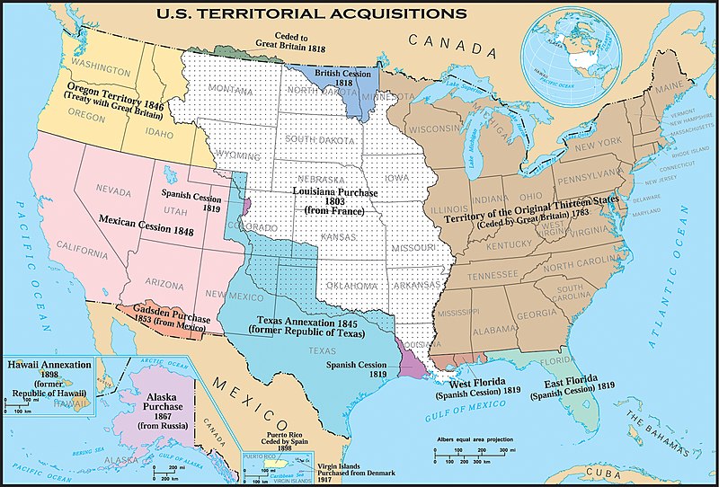
| Opis | United States historic territory acquisitions. Thirteen Colonies, Louisiana Purchase, British and Spanish Cession, ect. This map uses incorrect terms in that Great Britain didn't exist as a political entity in 1818 or 1846, having been superseded by the United Kingdom following the Act of Union with Ireland in 1801. |
| Datum | |
| Vir | |
| Avtor | Hewstep 20:08, 1 April 2006 (UTC) |
Licenca
This map was obtained from an edition of the National Atlas of the United States. Like almost all works of the U.S. federal government, works from the National Atlas are in the public domain in the United States.
Online access: NationalAtlas.gov | 1970 print edition: Library of Congress, Perry-Castañeda Library
|
Zgodovina datoteke
Kliknite datum in čas za ogled datoteke, ki je bila takrat naložena.
| Datum in čas | Sličica | Velikost | Uporabnik | Komentar | |
|---|---|---|---|---|---|
| trenutno | 09:29, 19. februar 2006 | | 1.550 × 1.051 (1,24 MB) | Aude | United States historic territory acquisitions Source: [http://www.nationalatlas.gov/ USGS National Atlas] Text labels modified (increased size), cropped, and converted to svg format by User:Kmf164 |
Uporaba datoteke
Datoteka je del naslednje 1 strani slovenske Wikipedije (strani drugih projektov niso navedene):
Globalna uporaba datoteke
To datoteko uporabljajo tudi naslednji vikiji:
- Uporaba na el.wikipedia.org
- Uporaba na en.wikipedia.org
- Uporaba na eo.wikipedia.org
- Uporaba na mwl.wikipedia.org
- Uporaba na pt.wikipedia.org