
Slika:Title Sheet, Index to Drawings - San Francisco Oakland Bay Bridge, Spanning San Francisco Bay, San Francisco, San Francisco County, CA HAER CAL,38-SANFRA,141- (sheet 1 of 20).png

Velikost tega predogleda: 800 × 545 točk. Druge ločljivosti: 320 × 218 točk | 640 × 436 točk | 1.024 × 698 točk | 1.280 × 872 točk | 2.560 × 1.744 točk | 14.411 × 9.819 točk.
Izvorna datoteka (14.411 × 9.819 točk, velikost datoteke: 6,08 MB, MIME-vrsta: image/png)
Spodaj prikazane informacije so s tamkajšnje opisne strani.
| Ta slika je JPEG-različica izvorne TIF-slike na File: Title Sheet, Index to Drawings - San Francisco Oakland Bay Bridge, Spanning San Francisco Bay, San Francisco, San Francisco County, CA HAER CAL,38-SANFRA,141- (sheet 1 of 20).tif.
Vendar naj kakršna koli sprememba te slike temelji na izvorni TIF-različici, da se prepreči nastanek izgube, in naj bosta posodobljeni obe različici. Ne opravljajte sprememb na podlagi te različice. |
Povzetek
| Opozorilo | Nekateri brskalniki bodo sliko v največji ločljivosti morda težko prikazali: slika ima veliko število točk in se morda ne bo naložila pravilno ali pa bo brskalnik zmrznil. |
|---|
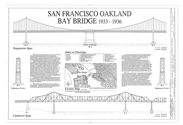
| Title Sheet, Index to Drawings - San Francisco Oakland Bay Bridge, Spanning San Francisco Bay, San Francisco, San Francisco County, CA | ||||
|---|---|---|---|---|
| Fotograf |
Goodman, Zachary, creator |
|||
| Naslov |
Title Sheet, Index to Drawings - San Francisco Oakland Bay Bridge, Spanning San Francisco Bay, San Francisco, San Francisco County, CA |
|||
| Upodobljeni kraj | California; San Francisco County; San Francisco | |||
| Datum | 1999 | |||
| Velikost | 24 x 36 in. (D size) | |||
| Lokacija |
Library of Congress Prints and Photographs Division Washington, D.C. 20540 USA http://hdl.loc.gov/loc.pnp/pp.print |
|||
| Inventarna številka |
HAER CAL,38-SANFRA,141- (sheet 1 of 20) |
|||
| Darovalec |
|
|||
| Opombe |
|
|||
| Sklici |
Related names:
|
|||
| Vir | https://www.loc.gov/pictures/item/ca1352.sheet.00001a | |||
| Dovoljenje (Nadaljnja uporaba datoteke) |
|
|||
| Druge različice |
.png) .png) .png) .png) .png) _-_San_Francisco_Oakland_Bay_Bridge,_Spanning_San_Francisco_Bay,_San_Francisco,_San_Francisco_County,_CA_HAER_CAL,38-SANFRA,141-_(sheet_14_of_20).png) .png) .png) .png) .png) .png) .png) .png) .png) _-_San_Francisco_Oakland_Bay_Bridge,_Spanning_San_Francisco_Bay,_San_Francisco,_San_Francisco_County,_CA_HAER_CAL,38-SANFRA,141-_(sheet_16_of_20).png) |
|||

.png)
| Lokacija objekta | | Ta in druge slike po lokaciji: OpenStreetMap |
|---|
.png¶ms=037.818056_N_-122.346667_E_globe:Earth_class:object_type:object__&language=sl)
Zgodovina datoteke
Kliknite datum in čas za ogled datoteke, ki je bila takrat naložena.
| Datum in čas | Sličica | Velikost | Uporabnik | Komentar | |
|---|---|---|---|---|---|
| trenutno | 04:22, 4. julij 2014 | | 14.411 × 9.819 (6,08 MB) | Fæ | {{Compressed version|file=File:Title_Sheet,_Index_to_Drawings_-_San_Francisco_Oakland_Bay_Bridge,_Spanning_San_Francisco_Bay,_San_Francisco,_San_Francisco_County,_CA_HAER_CAL,38-SANFRA,141-_(sheet_1_of_20).tif|thumb=nothumb}} =={{int:filedesc}}== {{Ph... |
Uporaba datoteke
Datoteka je del naslednje 1 strani slovenske Wikipedije (strani drugih projektov niso navedene):
Globalna uporaba datoteke
To datoteko uporabljajo tudi naslednji vikiji:
- Uporaba na en.wikipedia.org
- Uporaba na th.wikipedia.org
.png)