
Slika:Tectonics Sumatra quake.gif

Velikost tega predogleda: 463 × 599 točk. Drugi ločljivosti: 185 × 240 točk | 612 × 792 točk.
Izvorna datoteka (612 × 792 točk, velikost datoteke: 63 KB, MIME-vrsta: image/gif, 0,2 s)
Spodaj prikazane informacije so s tamkajšnje opisne strani.
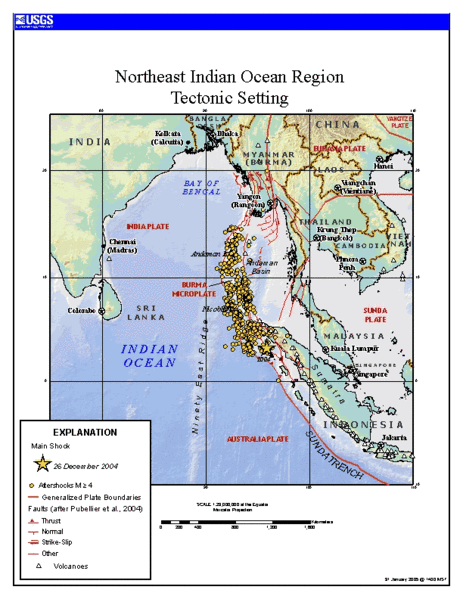
Source
https://earthquake.usgs.gov/eqinthenews/2004/usslav/ Tectonic setting of Sumatra earthquake - updated map (first maps posted by USGS was showing unrealistic plate boundaries)
This image is in the public domain in the United States because it only contains materials that originally came from the United States Geological Survey, an agency of the United States Department of the Interior. For more information, see the official USGS copyright policy.
|
Zgodovina datoteke
Kliknite datum in čas za ogled datoteke, ki je bila takrat naložena.
| Datum in čas | Sličica | Velikost | Uporabnik | Komentar | |
|---|---|---|---|---|---|
| trenutno | 14:24, 24. januar 2006 | | 612 × 792 (63 KB) | RobinL~commonswiki | ==Source== http://earthquake.usgs.gov/eqinthenews/2004/usslav/ Tectonic setting of Sumatra earthquake - updated map (first maps posted by USGS was showing unrealistic plate boundaries) {{PD-USGov-USGS}} |
Uporaba datoteke
Datoteka je del naslednje 1 strani slovenske Wikipedije (strani drugih projektov niso navedene):
Globalna uporaba datoteke
To datoteko uporabljajo tudi naslednji vikiji:
- Uporaba na ar.wikipedia.org
- Uporaba na ca.wikipedia.org
- Uporaba na el.wikipedia.org
- Uporaba na en.wikipedia.org
- Uporaba na es.wikipedia.org
- Uporaba na fa.wikipedia.org
- Uporaba na fr.wikipedia.org
- Uporaba na hi.wikipedia.org
- Uporaba na id.wikipedia.org
- Uporaba na ja.wikipedia.org
- Uporaba na ko.wikipedia.org
- Uporaba na my.wikipedia.org
- Uporaba na pt.wikipedia.org
- Uporaba na ru.wikipedia.org
- Uporaba na sr.wikipedia.org
- Uporaba na th.wikipedia.org
- Uporaba na tr.wikipedia.org
- Uporaba na uk.wikipedia.org
- Uporaba na zh.wikipedia.org