Slika:Ocean drainage.png
Vsebina strani ni podprta v drugih jezikih.
Iz Wikipedije, proste enciklopedije

Izvorna datoteka(1.256 × 656 točk, velikost datoteke: 75 KB, MIME-vrsta: image/png)


Povzetek

Ta zemljevid je mogoče poustvariti z uporabo vektorske grafike kot SVG-datoteko. To ima več prednosti; več informacij je na razpolago na strani Commons:Media for cleanup. Če je SVG-oblika te datoteke že na razpolago, jo, prosimo, naložite. Potem, ko boste SVG naložili, to predlogo zamenjajte z izrazom {{vector version available|ime nove slike.svg}}.
Opis
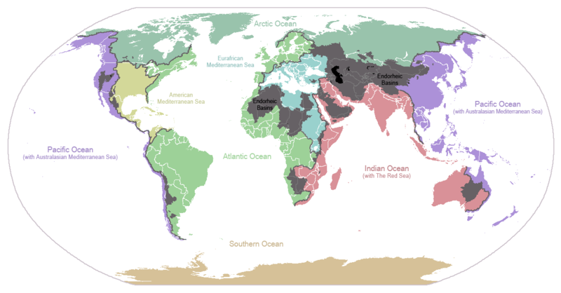
English: I made this map and hereby release it into the public domain. It shows the drainage basins for the major oceans and seas; grey areas are endorheic basins that do not drain to the ocean. Data is from the USGS Hydro1k project; information for Saskatchewan corrected by information from the Commission for Environmental Cooperation -- Citynoise
Description in large font size is used for oceans, in smaller font size is used for mediterranean seas. Only these mediterranean seas are listed which correspond to the definition of german Geographer Ernst Neef: A mediterranean sea is a sea between two Continents. Also found here: de:Mittelmeer --W like wiki (talk) 00:55, 12 March 2011 (UTC)
Français : Carte du monde des bassins versants. Les zones de couleur anthracite représentent les bassins endoréiques, qui ne sont reliés à aucun océan.
Čeština: Úmoří světových oceánů, popř. významných moří či zálivů. Legenda úmoří: fialová - Tichý oceán, růžová - Indický oceán, zelená - Atlantický oceán, azurová - Severní ledový oceán, béžová - Jižní oceán, modrá - Mexický záliv, světle modrá - Středozemní moře, šedá - oblast neústící ve světovém oceánu
Datum 24. januarja 2007 (izvirni datum naložitve)
Vir Iz en.wikipedia v Zbirko.
Avtor Citynoise, sodelavec projekta Wikipedija (jezik: angleščina).
Druge različice File:Major endorheic basins.png

Licenca

Public domain To delo je dal v javno domeno njegov avtor Citynoise, sodelavec projekta Wikipedija (jezik: angleščina).. To velja po vsem svetu.
V nekaterih državah to pravno morda ni mogoče. Če je tako,
Citynoise daje (v okviru zakonskih omejitev) vsakomur brezpogojno pravico, da gradivo uporablja v kateri koli namen.

Izvorni dnevniški zapis naložitve

Izvorna opisna stran je bila tukaj. Vsa nadaljnja uporabniška imena se nanašajo na en.wikipedia.
  • 2007-05-20 17:59 Bolonium 1256×656×8 (50194 bytes) I made this map and hereby release it into the public domain. It shows the drainage basins for the major oceans and seas; grey areas are endorheic basins that do not drain to the ocean. -- [[User:Citynoise|Citynoise]] == Licensing == {{self
  • 2007-01-24 07:21 Citynoise 1256×656×8 (63359 bytes) I made this map and hereby release it into the public domain. It shows the drainage basins for the major oceans and seas; grey areas are endorheic basins that do not drain to the ocean.
  • 2007-01-24 06:09 Citynoise 1256×656×8 (57358 bytes) I made this map and hereby release it into the public domain. It shows the drainage basins for the major oceans and seas; grey areas are endorheic basins that do not drain to the ocean.
  • 2007-01-24 05:10 Citynoise 1256×656×8 (56360 bytes) I made this map and hereby release it into the public domain. It shows the drainage basins for the major oceans and seas; grey areas are endorheic basins that do not drain to the ocean.
  • 2007-01-24 04:55 Citynoise 1256×656×8 (56373 bytes) I made this map and hereby release it into the public domain. It shows the drainage basins for the major oceans and seas; grey areas are endorheic basins that do not drain to the ocean.

Napisi

Dodajte enovrstični opis, kaj ta datoteka predstavlja
Drainage basins of the world, colored by ocean outlet. Endorheic basins not draining to an ocean are colored dark gray. Continental divides are indicated by dark lines.

Predmeti, prikazani v tej datoteki

motiv

24. januar 2007

Zgodovina datoteke

Kliknite datum in čas za ogled datoteke, ki je bila takrat naložena.

Datum in časSličicaVelikostUporabnikKomentar
trenutno01:25, 7. oktober 2015Sličica za različico z datumom 01:25, 7. oktober 20151.256 × 656 (75 KB)AcidSnowFixed Somalia.
02:39, 12. marec 2011Sličica za različico z datumom 02:39, 12. marec 20111.256 × 656 (76 KB)W like wikiInsert Description. Big font size is used for oceans, smaller font size is used for mediterranean seas.
13:13, 30. junij 2009Sličica za različico z datumom 13:13, 30. junij 20091.256 × 656 (40 KB)U7vGuntransparentize background,improve some details.
22:45, 26. julij 2008Sličica za različico z datumom 22:45, 26. julij 20081.256 × 656 (62 KB)Citynoise{{Information |Description=added endorheic basins in Saskatchewan. |Source=my own work |Date=July 2008 |Author=Citynoise |Permission=all rights released |other_versions= }}
21:46, 27. november 2007Sličica za različico z datumom 21:46, 27. november 20071.256 × 656 (49 KB)File Upload Bot (Magnus Manske) {{BotMoveToCommons|en.wikipedia}} {{Information |Description={{en|I made this map and hereby release it into the public domain. It shows the drainage basins for the major oceans and seas; grey areas are en:endorheic basins that do not drain to the

Datoteka je del naslednje 1 strani slovenske Wikipedije (strani drugih projektov niso navedene):

Globalna uporaba datoteke

To datoteko uporabljajo tudi naslednji vikiji:

Oglejte si globalno uporabo te datoteke.

Metapodatki