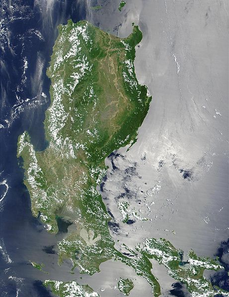
Slika:Northern Philippines (Luzon).jpg

Velikost tega predogleda: 461 × 599 točk. Druge ločljivosti: 184 × 240 točk | 369 × 480 točk | 591 × 768 točk | 788 × 1.024 točk | 2.000 × 2.600 točk.
Izvorna datoteka (2.000 × 2.600 točk, velikost datoteke: 738 KB, MIME-vrsta: image/jpeg)
Zgodovina datoteke
Kliknite datum in čas za ogled datoteke, ki je bila takrat naložena.
| Datum in čas | Sličica | Velikost | Uporabnik | Komentar | |
|---|---|---|---|---|---|
| trenutno | 23:52, 25. oktober 2005 |  | 2.000 × 2.600 (738 KB) | Brian0918 | * Credit Jacques Descloitres, MODIS Land Rapid Response Team, NASA/GSFC This MODIS true-color image of the northern Philippines shows the island of Luzon and the Cagayan River running in the plains between the Sierra Madre mountain rang |
Uporaba datoteke
Datoteka je del naslednje 1 strani slovenske Wikipedije (strani drugih projektov niso navedene):
Globalna uporaba datoteke
To datoteko uporabljajo tudi naslednji vikiji:
- Uporaba na af.wikipedia.org
- Uporaba na ar.wikipedia.org
- Uporaba na arz.wikipedia.org
- Uporaba na ast.wikipedia.org
- Uporaba na ba.wikipedia.org
- Uporaba na be-tarask.wikipedia.org
- Uporaba na be.wikipedia.org
- Uporaba na bg.wikipedia.org
- Uporaba na bjn.wikipedia.org
- Uporaba na bo.wikipedia.org
- Uporaba na ca.wikipedia.org
- Uporaba na cy.wikipedia.org
- Uporaba na de.wikipedia.org
- Uporaba na el.wikipedia.org
- Uporaba na en.wikipedia.org
- Uporaba na eo.wikipedia.org
- Uporaba na es.wikipedia.org
- Uporaba na et.wikipedia.org
- Uporaba na eu.wikipedia.org
- Uporaba na fa.wikipedia.org
- Uporaba na fi.wiktionary.org
- Uporaba na fr.wikipedia.org
- Uporaba na fr.wikivoyage.org
- Uporaba na ga.wikipedia.org
- Uporaba na he.wikipedia.org
- Uporaba na hu.wikipedia.org
- Uporaba na hy.wikipedia.org
- Uporaba na ia.wikipedia.org
- Uporaba na id.wikipedia.org
- Uporaba na id.wiktionary.org
- Uporaba na incubator.wikimedia.org
- Uporaba na jv.wikipedia.org
- Uporaba na ka.wikipedia.org
- Uporaba na ky.wikipedia.org
- Uporaba na lv.wikipedia.org
- Uporaba na ms.wikipedia.org
- Uporaba na nn.wikipedia.org
- Uporaba na os.wikipedia.org
- Uporaba na pl.wikipedia.org
Oglejte si globalno uporabo te datoteke.


