
Slika:Mid-ocean ridge topography.gif
Višja ločljivost ni na voljo.
Mid-ocean_ridge_topography.gif (240 × 180 točk, velikost datoteke: 1,06 MB, MIME-vrsta: image/gif, ponavljajoče, 70 sličic, 14 s)
Spodaj prikazane informacije so s tamkajšnje opisne strani.
Povzetek
| Opis |
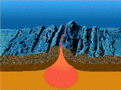
English: A close-up showing mid-ocean ridge topography with magma chamber below, which rises and new ocean plates spreads away from ridge. |
| Datum | |
| Vir | http://geomaps.wr.usgs.gov/parks/animate/index.html |
| Avtor | USGS |
Licenca
This image is in the public domain in the United States because it only contains materials that originally came from the United States Geological Survey, an agency of the United States Department of the Interior. For more information, see the official USGS copyright policy.
|
Zgodovina datoteke
Kliknite datum in čas za ogled datoteke, ki je bila takrat naložena.
| Datum in čas | Sličica | Velikost | Uporabnik | Komentar | |
|---|---|---|---|---|---|
| trenutno | 17:04, 19. februar 2011 | | 240 × 180 (1,06 MB) | דקי | {{Information |Description ={{en|1=A close-up showing mid-ocean ridge topography with magma chamber below, which rises and new ocean plates spreads away from ridge.}} |Source =http://geomaps.wr.usgs.gov/parks/animate/index.html |Author |
Uporaba datoteke
Datoteka je del naslednje 1 strani slovenske Wikipedije (strani drugih projektov niso navedene):
Globalna uporaba datoteke
To datoteko uporabljajo tudi naslednji vikiji:
- Uporaba na an.wikipedia.org
- Uporaba na ar.wikipedia.org
- Uporaba na ast.wikipedia.org
- Uporaba na az.wikipedia.org
- Uporaba na bg.wikipedia.org
- Uporaba na ca.wikipedia.org
- Uporaba na de.wikipedia.org
- Uporaba na de.wiktionary.org
- Uporaba na en.wikipedia.org
- Uporaba na en.wikiquote.org
- Uporaba na es.wikipedia.org
- Uporaba na eu.wikipedia.org
- Uporaba na fi.wikipedia.org
- Uporaba na fr.wikipedia.org
- Uporaba na gl.wikipedia.org
- Uporaba na he.wikipedia.org
- Uporaba na hi.wikipedia.org
- Uporaba na hu.wikipedia.org
- Uporaba na it.wikipedia.org
- Uporaba na it.wikibooks.org
- Uporaba na it.wikiversity.org
- Uporaba na ja.wikipedia.org
- Uporaba na ja.wikibooks.org
- Uporaba na ko.wikipedia.org
- Uporaba na kw.wikipedia.org
- Uporaba na lv.wikipedia.org
- Uporaba na mk.wikipedia.org
Oglejte si globalno uporabo te datoteke.