
Slika:Goreme National Park, Turkey.jpg

Velikost tega predogleda: 600 × 600 točk. Druge ločljivosti: 240 × 240 točk | 480 × 480 točk | 768 × 768 točk | 1.024 × 1.024 točk | 2.400 × 2.400 točk.
Izvorna datoteka (2.400 × 2.400 točk, velikost datoteke: 2,77 MB, MIME-vrsta: image/jpeg)
Spodaj prikazane informacije so s tamkajšnje opisne strani.
Povzetek
| Opis |
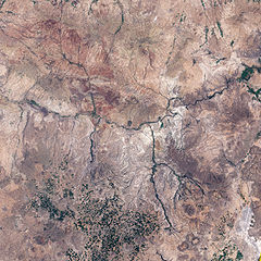
English: This is an image of Göreme National Park and its surroundings in Cappadocia, Turkey. A black outline delineates park boundaries.
|
| Datum | |
| Vir | NASA Earth Observatory |
| Avtor | Jesse Allen |
Image created using Landsat data provided by the United States Geological Survey. Instrument: Landsat 7 - ETM+
Licenca
| Ta datoteka je v javni domeni, ker jo je izdelala izključno NASA. Avtorskopravna politika NASE pravi, da »Gradivo NASE ni zaščiteno z avtorskimi pravicami, razen če je rečeno drugače.« (glej Template:PD-USGov, stran z avtorskopravno politiko NASE ali Politiko uporabe slik JPL.) | ||
 |
Opozorila:
|
Zgodovina datoteke
Kliknite datum in čas za ogled datoteke, ki je bila takrat naložena.
| Datum in čas | Sličica | Velikost | Uporabnik | Komentar | |
|---|---|---|---|---|---|
| trenutno | 11:53, 7. junij 2009 | | 2.400 × 2.400 (2,77 MB) | Originalwana | {{Information |Description={{en|1=This is an image of Göreme National Park and its surroundings in Cappadocia. A black outline delineates park boundaries. Although the satellite’s perspective doesn't quite match the spectacular scenery from the ground, |
Uporaba datoteke
Datoteka je del naslednje 1 strani slovenske Wikipedije (strani drugih projektov niso navedene):
Globalna uporaba datoteke
To datoteko uporabljajo tudi naslednji vikiji: