
Slika:Europe 1783-1792 en.png

Velikost tega predogleda: 800 × 570 točk. Druge ločljivosti: 320 × 228 točk | 640 × 456 točk | 1.024 × 730 točk | 1.280 × 913 točk | 2.560 × 1.825 točk | 3.872 × 2.761 točk.
Izvorna datoteka (3.872 × 2.761 točk, velikost datoteke: 1,24 MB, MIME-vrsta: image/png)
Spodaj prikazane informacije so s tamkajšnje opisne strani.
_en.png)
.png)
.jpg)
Povzetek
| Opis |
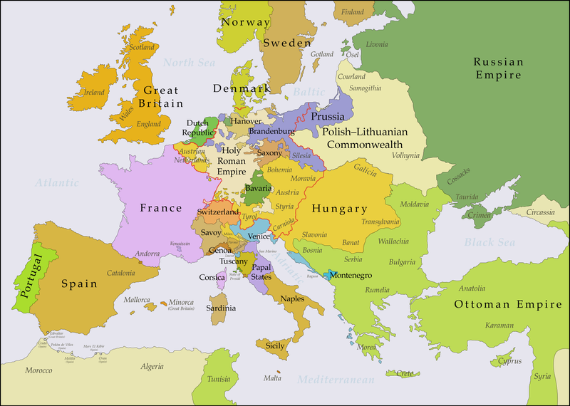
English: This map shows Europe in the years between the 1783 Russian annexation of Crimea after the Russo-Turkish War of 1768–1774 and the Russian annexation of Yedisan in 1792 at the end of the Russo-Turkish War of 1787–1792. The red line marks the borders of the Holy Roman Empire. The work was created with Inkscape and is mainly based on a map in: Putzger - Historischer Weltatlas, Berlin 1990, 78 pp. |
| Datum | |
| Vir | lastno delo, based on File:Europe 1748-1766 en.png |
| Avtor | Bryan Rutherford |
Licenca
Jaz, imetnik avtorskih pravic na tem delu, ga objavljam pod naslednjo licenco:
Datoteka je objavljena pod licenco Creative Commons Priznanje avtorstva-Deljenje pod enakimi pogoji 4.0 Mednarodno.
- Dovoljeno vam je:
- deljenje – reproducirati, distribuirati in javno priobčevati delo
- predelava – predelati delo
- Pod naslednjimi pogoji:
- priznanje avtorstva – Navesti morate ustrezno avtorstvo, povezavo do licence in morebitne spremembe. To lahko storite na kakršen koli primeren način, vendar ne na način, ki bi nakazoval, da dajalec licence podpira vas ali vašo uporabo dela.
- deljenje pod enakimi pogoji – Če boste to vsebino predelali, preoblikovali ali uporabili kot izhodišče za drugo delo, morate svoj prispevek distribuirati pod enako ali združljivo licenco, kot jo ima izvirnik.
| Annotations | This image is annotated: View the annotations at Commons |
Zgodovina datoteke
Kliknite datum in čas za ogled datoteke, ki je bila takrat naložena.
| Datum in čas | Sličica | Velikost | Uporabnik | Komentar | |
|---|---|---|---|---|---|
| trenutno | 23:47, 15. julij 2018 | | 3.872 × 2.761 (1,24 MB) | Bryanrutherford0 | Added the Ionian Islands, made the Duchy of Milan a Habsburg possession, gave Prussia control of Mansfeld (1780) |
| 04:29, 10. julij 2018 |  | 3.872 × 2.761 (1,23 MB) | Bryanrutherford0 | Added Comtat Venaissin and redrew borders of Neuchâtel, Bishopric Basel, and Montbéliard | |
| 02:46, 3. oktober 2017 |  | 3.872 × 2.761 (1,23 MB) | Bryanrutherford0 | Transferred control of Saaremaa and Hiiumaa to Russia (1721 Treaty of Nystad), transferred control of Corsica to France (1769 [[:en:French conquest of Corsica|French conquest of... | |
| 17:03, 30. september 2017 |  | 3.872 × 2.761 (1,23 MB) | Bryanrutherford0 | Adjusted Russian-Swedish border in Finland to reflect Russian gains in the 1743 Treaty of Åbo after the Russo-Swedish War. | |
| 06:47, 30. september 2017 |  | 3.872 × 2.761 (1,23 MB) | Bryanrutherford0 | User created page with UploadWizard |
Uporaba datoteke
Datoteka je del naslednje 1 strani slovenske Wikipedije (strani drugih projektov niso navedene):
Globalna uporaba datoteke
To datoteko uporabljajo tudi naslednji vikiji:
- Uporaba na ar.wikipedia.org
- Uporaba na bg.wikipedia.org
- Uporaba na bn.wikipedia.org
- Uporaba na br.wikipedia.org
- Uporaba na ca.wikipedia.org
- Uporaba na el.wikipedia.org
- Uporaba na en.wikipedia.org
- Uporaba na es.wikipedia.org
- Uporaba na fi.wikipedia.org
- Uporaba na fr.wikipedia.org
- Uporaba na it.wikipedia.org
- Uporaba na ja.wikipedia.org
- Uporaba na ka.wikipedia.org
- Uporaba na mk.wikipedia.org
- Uporaba na th.wikipedia.org
- Uporaba na tl.wikipedia.org
- Uporaba na uz.wikipedia.org
- Uporaba na vi.wikipedia.org
- Uporaba na zh.wikipedia.org