
Slika:Croatia of Tomislav-slo.PNG

Velikost tega predogleda: 800 × 597 točk. Druge ločljivosti: 320 × 239 točk | 640 × 477 točk | 901 × 672 točk.
Izvorna datoteka (901 × 672 točk, velikost datoteke: 154 KB, MIME-vrsta: image/png)
Spodaj prikazane informacije so s tamkajšnje opisne strani.
| Opis |
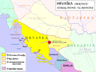
English: Map of Croatia during the last years of Tomislav's reign. This map is based on the written sources in: 1. Klaić (1990). Pages 72-74- for descriptions of Slavonia region and Bulgarians; 2. Goldstein (2008). Pages 37-38- for descriptions Slavonia region and Bulgarians; 3. Voje (1994). Page 54 for Slavonia region, page 68 for Bulgarians, pages 79-81 for description of serbian lands; 4. Štih Peter (2001). Ozemlje Slovenije v zgodnjem srednjem veku. Ljubljana, Filozofska fakulteta. Page 82 for description of slovenian lands after Hungarian conquest. For retrospective approach look at the map f Hungary at the and of 11th century- in 1. Kontler Laszlo (2005): Madžarska zgodovina. Ljubljana, Slovenska matica. Page 65. |
| Datum | (UTC) |
| Vir | |
| Avtor |
|
| Ta slika je digitalno obdelana. Opravljene so bile naslednje spremembe: Part of the map was used to create a new historical map.. Izvirnik je na voljo tukaj: Waterways of SE Central Europe.svg. Spremembe je opravil uporabnik ''Bostjan46''.
|
Jaz, imetnik avtorskih pravic na tem delu, ga objavljam pod naslednjo licenco:
| Jaz, imetnik avtorskih pravic na tem delu, izročam to delo v javno domeno. To velja po vsem svetu. V nekaterih državah to pravno morda ni mogoče. Če je tako, Vsakomur dajem (v okviru zakonskih omejitev) brezpogojno pravico, da gradivo uporablja v kateri koli namen. |
Izvorni dnevniški zapis naložitve
This image is a derivative work of the following images:
- File:Waterways_of_SE_Central_Europe.svg licensed with PD-self
- 2010-01-08T20:49:27Z Kmiki87 1415x1059 (292577 Bytes) {{Information |Description={{en|1=Waterways along the central and lower Danube, including the Bohemian and Carpathian Basins, the northern Balkans, parts of Austria, southern Poland and Western Ukraine.}} |Source={{own}} |Aut
Uploaded with derivativeFX
Zgodovina datoteke
Kliknite datum in čas za ogled datoteke, ki je bila takrat naložena.
| Datum in čas | Sličica | Velikost | Uporabnik | Komentar | |
|---|---|---|---|---|---|
| trenutno | 16:52, 20. februar 2022 | | 901 × 672 (154 KB) | Luigimini | There were no "mixed influences". Slavonia was croatian since Tomislav beat the Hungarians in 925. Vassals. https://upload.wikimedia.org/wikipedia/hr/1/1b/Tomislavova_Hrvatska.jpg |
| 16:24, 20. februar 2022 |  | 901 × 672 (161 KB) | Luigimini | This map is based on unreliable and sources that display croatia in a different time period. Mainstream historiography agrees with the map of Ferdo Šišić, Stjepan Srkulja and other 20th cent. croatian historians (see: https://upload.wikimedia.org/wikipedia/hr/thumb/1/1b/Tomislavova_Hrvatska.jpg/800px-Tomislavova_Hrvatska.jpg) Kotor was under Byzantium, Serbian areas are more eastern, hum trabunia and dioclea were vassal states of Croatia. Slavonia was constantly croatian since Tomislav beat t... | |
| 18:31, 16. avgust 2010 |  | 901 × 672 (120 KB) | Bostjan46 | The region of Dioclea has no reliable data- the supremacy of Byzantium has been put under the question. | |
| 15:04, 15. avgust 2010 |  | 901 × 672 (120 KB) | Bostjan46 | {{Information |Description={{en|1=Map of Croatia during the last years of Tomislav's reign. This map is based on the '''maps''' of 1. Klaić Nada (1990). ''Povijest Hrvata u srednjem vijeku''. Zagreb, Globus. Painted on Cover; 2. Voje Ignacij (1994). '' |
Uporaba datoteke
Datoteka je del naslednjih 3 strani slovenske Wikipedije (strani drugih projektov niso navedene):
Globalna uporaba datoteke
To datoteko uporabljajo tudi naslednji vikiji:
- Uporaba na sh.wikipedia.org