Slika:Brandberg Massif Landsat Image.jpg

Vsebina strani ni podprta v drugih jezikih.
Iz Wikipedije, proste enciklopedije

Izvorna datoteka(1.000 × 1.000 točk, velikost datoteke: 215 KB, MIME-vrsta: image/jpeg)


Povzetek

Opis
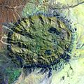
English: Satellite image of the Brandberg Massif, Namibia. Original figure caption: “Brandberg Massif is a dome-shaped granite intrusion that covers 250 square miles (650 square kilometers) and rises 1.6 miles (2,573 meters) above its surroundings in the central Namib Desert. Brandberg Massif is an important habitat for high-altitude savannah species and is of great archaeological interest due to the many prehistoric cave paintings found among its granite cliffs.
Deutsch: Satellitenbild des Brandberg Massivs, Namibia. Original Bildbeschriftung (modifizierte Übersetzung): Das Brandbergmassiv ist eine kuppelförmige Granit-Intrusion, deren Ausbiss sich über 650 Quadratkilometer erstreckt und sich 2.573 Meter über sein Umland in der zentralen Namib-Wüste erhebt. Das Brandberg-Massiv ist ein wichtiger Lebensraum für Pflanzen- und Tierarten der Hochlandsavanne und von hohem archäologischem Interesse aufgrund der zahlreichen frühgeschichtlichen Höhlenmalereien in seinen Granitklippen.
Datum 10. septembra 2002 (“acquisition date”)
Vir http://landsat.usgs.gov/images/gallery/26_L.jpg
Avtor USGS

Licenca

Public domain
This image is in the public domain in the United States because it only contains materials that originally came from the United States Geological Survey, an agency of the United States Department of the Interior. For more information, see the official USGS copyright policy.

Bahasa Indonesia  català  čeština  Deutsch  eesti  English  español  français  galego  italiano  Nederlands  português  polski  sicilianu  suomi  Tiếng Việt  Türkçe  български  македонски  русский  മലയാളം  한국어  日本語  中文  中文(简体)  中文(繁體)  العربية  فارسی  +/−

Napisi

Dodajte enovrstični opis, kaj ta datoteka predstavlja

Predmeti, prikazani v tej datoteki

motiv

10. september 2002

image/jpeg

14cdf2233bc91a9172ec853bb25bd2890573a295

način določitve: SHA-1 angleščina

220.169 zlog

1.000 piksel

1.000 piksel

Zgodovina datoteke

Kliknite datum in čas za ogled datoteke, ki je bila takrat naložena.

Datum in časSličicaVelikostUporabnikKomentar
trenutno01:41, 24. avgust 2005Sličica za različico z datumom 01:41, 24. avgust 20051.000 × 1.000 (215 KB)Atamari{{PD-USGov-USGS}} * Brandberg Massif, Namibia * Acquisition Date:Sep 10,2002 * source http://landsat.usgs.gov/gallery/detail/367/ category:Namibia

Datoteka je del naslednje 1 strani slovenske Wikipedije (strani drugih projektov niso navedene):

Globalna uporaba datoteke

To datoteko uporabljajo tudi naslednji vikiji:

Metapodatki