
Slika:ReliefUSA map.gif
Višja ločljivost ni na voljo.
ReliefUSA_map.gif (714 × 496 točk, velikost datoteke: 228 KB, MIME-vrsta: image/gif)
Spodaj prikazane informacije so s tamkajšnje opisne strani.
Povzetek
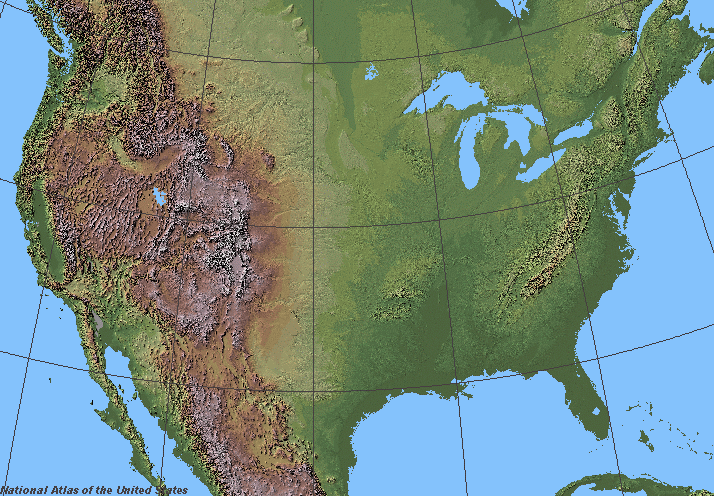
Shaded relief in the lower 48 states of the United States of America.
Licenca
This map was obtained from an edition of the National Atlas of the United States. Like almost all works of the U.S. federal government, works from the National Atlas are in the public domain in the United States.
Online access: NationalAtlas.gov | 1970 print edition: Library of Congress, Perry-Castañeda Library
|
derivative works
Izpeljana dela te datoteke:
Zgodovina datoteke
Kliknite datum in čas za ogled datoteke, ki je bila takrat naložena.
| Datum in čas | Sličica | Velikost | Uporabnik | Komentar | |
|---|---|---|---|---|---|
| trenutno | 08:07, 5. junij 2006 | | 714 × 496 (228 KB) | Urban~commonswiki | ==Description== Shaded relief in the lower 48 states of the United States of America. ==License== {{PD-USGov-Atlas}} |
Uporaba datoteke
Datoteka je del naslednje 1 strani slovenske Wikipedije (strani drugih projektov niso navedene):
Globalna uporaba datoteke
To datoteko uporabljajo tudi naslednji vikiji:
- Uporaba na fr.wikipedia.org
- Wikipédia:Wikiconcours/mars 2008/Équipes
- Discussion Wikipédia:Wikiconcours/mars 2008/Équipes/Équipe 10
- Discussion Wikipédia:Wikiconcours/mars 2008/Équipes/Équipe 10/Mammoth
- Discussion Wikipédia:Wikiconcours/mars 2008/Équipes/Équipe 10/Denver
- Discussion Wikipédia:Wikiconcours/mars 2008/Équipes/Équipe 10/Baltimore
- Discussion Wikipédia:Wikiconcours/mars 2008/Équipes/Équipe 10/Glacier
- Discussion Wikipédia:Wikiconcours/mars 2008/Équipes/Équipe 10/Modèle
- Discussion Wikipédia:Wikiconcours/mars 2008/Équipes/Équipe 10/Louisville
- Uporaba na sco.wikipedia.org