
Slika:Map Saipan Tinian islands closer.jpg
Višja ločljivost ni na voljo.
Map_Saipan_Tinian_islands_closer.jpg (290 × 410 točk, velikost datoteke: 31 KB, MIME-vrsta: image/jpeg)
Spodaj prikazane informacije so s tamkajšnje opisne strani.
Povzetek
| Opis |
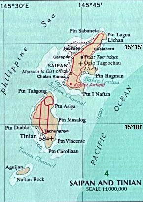
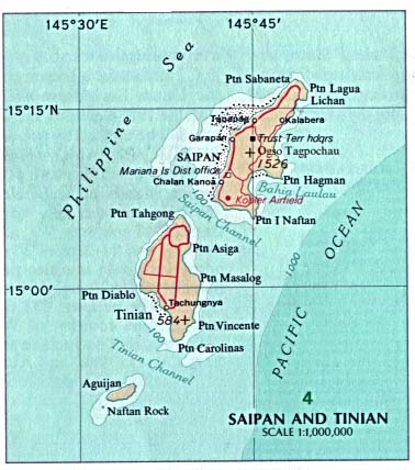
English: Map of the islands of Saipan and Tinian in the Northern Mariana Islands along the Marianas Trench (east of China and the Philippines). |
| Datum | |
| Vir |
Derived by cropping US Government (USNA) map: http://www.lib.utexas.edu/maps/australia/saipan_tinian_islands.jpg linked as being a US National Atlas (1970) map on related webpage: http://www.lib.utexas.edu/maps/northern_mariana_islands.html . |
| Avtor |
map:US Geological Survey |
| Druge različice |
 |
Licenca
The map is public domain, derived by User:Wikid77 from a USNA image (in JPEG format).
This image is in the public domain in the United States because it only contains materials that originally came from the United States Geological Survey, an agency of the United States Department of the Interior. For more information, see the official USGS copyright policy.
|
Zgodovina datoteke
Kliknite datum in čas za ogled datoteke, ki je bila takrat naložena.
| Datum in čas | Sličica | Velikost | Uporabnik | Komentar | |
|---|---|---|---|---|---|
| trenutno | 16:32, 7. marec 2008 | | 290 × 410 (31 KB) | Wikid77 | initial upload |
Uporaba datoteke
Datoteka je del naslednje 1 strani slovenske Wikipedije (strani drugih projektov niso navedene):
Globalna uporaba datoteke
To datoteko uporabljajo tudi naslednji vikiji:
- Uporaba na cs.wikipedia.org
- Uporaba na el.wikipedia.org
- Uporaba na en.wikipedia.org
- Uporaba na eu.wikipedia.org
- Uporaba na fa.wikipedia.org
- Uporaba na ha.wikipedia.org
- Uporaba na hi.wikipedia.org
- Uporaba na id.wikipedia.org
- Uporaba na it.wikipedia.org
- Uporaba na ka.wikipedia.org
- Uporaba na ml.wikipedia.org
- Uporaba na nl.wikipedia.org
- Uporaba na ps.wikipedia.org
- Uporaba na pt.wikipedia.org
- Uporaba na tr.wikipedia.org
- Uporaba na uk.wikipedia.org
- Uporaba na vi.wikipedia.org