Slika:Europe in 1345.png

Vsebina strani ni podprta v drugih jezikih.
Iz Wikipedije, proste enciklopedije

Izvorna datoteka(1.075 × 1.168 točk, velikost datoteke: 114 KB, MIME-vrsta: image/png)


Povzetek

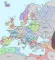
Opis A map of Europe in 1345, showing the location of events that took place in that year. The Black Plague's exact location in unknown, and the shaded area to the right represents rough scholarly estimates. It hit the Crimea in the following year.
Datum
Vir self-made from Image:Europein1328.png with GIMP
Avtor Teaandcrumpets
To sliko je mogoče poustvariti z uporabo vektorske grafike kot SVG-datoteko. To ima več prednosti; več informacij je na razpolago na strani Commons:Media for cleanup. Če je SVG-oblika te datoteke že na razpolago, jo, prosimo, naložite. Potem, ko boste SVG naložili, to predlogo zamenjajte z izrazom {{vector version available|ime nove slike.svg}}.
Maps of the history of Europe
BCE
aC

Weichselian ice age (c. 113,000–9700) · Neolithic expansion (c. 7000–4500) · Middle Neolithic (c. 4500–4000) · Late Neolithic (c. 4000–3000) · Copper Age – Corded Ware culture (c. 2900–2350) · Copper Age – Bellbeaker culture (c. 2800–1800) · Early Bronze Age – Unetice culture (c. 2300–1600) · Late Bronze Age – Urnfield culture (c. 1300—750) · Migrations (c. 1000–100) · Hallstatt & La Tène cultures (c. 800–100) · Roman Republic (510–40) · 220 · 218 · 200 · 201–100 · 58 · 49 · 39 · 30 BCE–6 CE


CE
dC

14 · 14–37 · 60 · 60 · 69 · 80 · Migrations 100–500 · 117 · 117 · 125 · Migrations 150–774 · Economy 180 · 271 · 293–305 · 337 · 395 · c. 395 · 400 · 400 · 450 · 457–61 · 476 · 480 · Franks 481–814 · Early Slavs 500–700 · 500 · 526 · 526–600 · Christianisation to 600 · c. 550 · 650 · Pontic Steppe 650 · 665 · 800 · Vikings 800–1050 · 814 · 843–70 · 850 · 900 · 912 · 998 · 1000 · 1000 · 1054 · 1092 · First Crusade 1095–99 · 1097 · 1135 · 1142 · 1147–49 · 1190 · 1190 · 1250 · c. 1250 · 1301-1400 · 1301-1400 · 1328 · 1345 · Black Plague 1347–51 · 1360 · 1400 · Trade routes c. 1400 · 1430 · 1470 · 1490 · 1492 · 1500 · 1519 · 1550 · 1560 · Religion 1560 · Religion 1600 · Religion 1618 · 1618–48 · 1648 · 1683 · 1700 · 1701 · 1708 · 1714 · 1721 · 1725–30 · 1739–1740 · 1740 · 1748–66 · 1783–1792 · 1787 · 1787 · 1789 · 1799 · 1812 · 1812 · 1812 · 1812 · 1813 · 1815 · 1815 · 1815 · 1818 · Ottoman Empire 1830–1923 · 1848–49 · 1861 · 1867 · 1871 · 1878 · 1890 · 1905 · 1911 · 1914 · 1914 · 1919 · 1919–29 · 1923 · 1929 · 1930 · 1940 · 1941–42 · 1942–45 · Cold War 1947–91 · 1950 · 1993–2006 · 2006 to date

(this template: · view · discuss )

Licenca

Public domain Jaz, imetnik avtorskih pravic na tem delu, izročam to delo v javno domeno. To velja po vsem svetu.
V nekaterih državah to pravno morda ni mogoče. Če je tako,
Vsakomur dajem (v okviru zakonskih omejitev) brezpogojno pravico, da gradivo uporablja v kateri koli namen.

Napisi

Dodajte enovrstični opis, kaj ta datoteka predstavlja

Predmeti, prikazani v tej datoteki

motiv

13. november 2007

Zgodovina datoteke

Kliknite datum in čas za ogled datoteke, ki je bila takrat naložena.

Datum in časSličicaVelikostUporabnikKomentar
trenutno21:31, 10. maj 2020Sličica za različico z datumom 21:31, 10. maj 20201.075 × 1.168 (114 KB)Santasa99Corrections per Euroatlas - Historical Maps, http://www.euratlas.net/history/europe/1300/index.html Euratlas Periodis Web - Map of Europe in Year 1300
14:58, 24. december 2017Sličica za različico z datumom 14:58, 24. december 20171.075 × 1.168 (289 KB)Trey KincaidChanged Sicily who had his own kingdom
21:30, 1. julij 2012Sličica za različico z datumom 21:30, 1. julij 20121.075 × 1.168 (282 KB)Ludde23Changed Estonia from the red color of Sweden to the yellow color of Denmark, since Estonia was not Swedish at this time, but belonged to Denmark until 1346.
23:34, 24. april 2009Sličica za različico z datumom 23:34, 24. april 20091.075 × 1.168 (112 KB)Alex:DBorders corrected
20:02, 15. november 2007Sličica za različico z datumom 20:02, 15. november 20071.075 × 1.168 (110 KB)Teaandcrumpets(changed notre dame marker)
01:03, 14. november 2007Sličica za različico z datumom 01:03, 14. november 20071.075 × 1.168 (113 KB)Teaandcrumpets{{Information |Description= A map of Europe in 1345, showing the location of events that took place in that year. |Source=self-made from Image:Europein1328.png with GIMP |Date= 13 Nov 2007 |Author= Teaandcrumpets |Permission=

Datoteka je del naslednje 1 strani slovenske Wikipedije (strani drugih projektov niso navedene):

Globalna uporaba datoteke

To datoteko uporabljajo tudi naslednji vikiji:

Metapodatki