
Slika:EasternRomanEmpire.png
Višja ločljivost ni na voljo.
EasternRomanEmpire.png (250 × 175 točk, velikost datoteke: 7 KB, MIME-vrsta: image/png)
Spodaj prikazane informacije so s tamkajšnje opisne strani.

|
This map has been uploaded by Electionworld from en.wikipedia.org to enable the |

|
Imetnik avtorskih pravic na tem delu vsakomur dovoljuje uporabo v kateri koli namen, vključno z neomejenim razširjanjem, pridobitno uporabo in spreminjanjem.
|
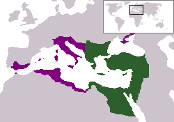
The territory in green represents the core areas held by the Eastern Roman Empire before the Muslim conquests The territory in purple represents the greatest extent of the Byzantine Empire under Emperor Justinian I
Zgodovina datoteke
Kliknite datum in čas za ogled datoteke, ki je bila takrat naložena.
| Datum in čas | Sličica | Velikost | Uporabnik | Komentar | |
|---|---|---|---|---|---|
| trenutno | 20:27, 13. december 2006 | | 250 × 175 (7 KB) | Electionworld | {{ew|en|24630}} {{CopyrightedFreeUse-User|24630}} The territory in green represents the core areas held by the Eastern Roman Empire before the Muslim conquests The territory in purple represents the greatest extent of the Byzantine Empire unde |
Uporaba datoteke
Datoteka je del naslednje 1 strani slovenske Wikipedije (strani drugih projektov niso navedene):
Globalna uporaba datoteke
To datoteko uporabljajo tudi naslednji vikiji:
- Uporaba na da.wikipedia.org
- Uporaba na en.wiktionary.org
- Uporaba na gd.wikipedia.org
- Uporaba na lv.wikipedia.org
- Uporaba na no.wikipedia.org
- Uporaba na ru.wiktionary.org
- Uporaba na sq.wikipedia.org
- Uporaba na sv.wikipedia.org
- Uporaba na vi.wikipedia.org
- Uporaba na zh.wiktionary.org